
Hiking Clearwater Falls Trail
With almost one million acres of forest (983,129 to be exact), Umpqua National Forest is one place that doesn’t disappoint. The forest stretches from just north of Crater Lake National Park and spans to the western edges of the southern Cascade ranges . Within its boundaries are an abundance of culture, lakes, waterfalls, enchanting forests, and snow-capped volcanic domes.
The Clearwater Falls trail takes place along the Rogue-Umpqua National Scenic Byway. This scenic highway travels through the heavily forested Southern Cascade ranges and is 172 miles long. Clearwater Falls is one of the many waterfalls that are of easy access off this highway. This particular waterfall is off of the beautiful Highway 138 and one of many waterfalls off this stretch of road.
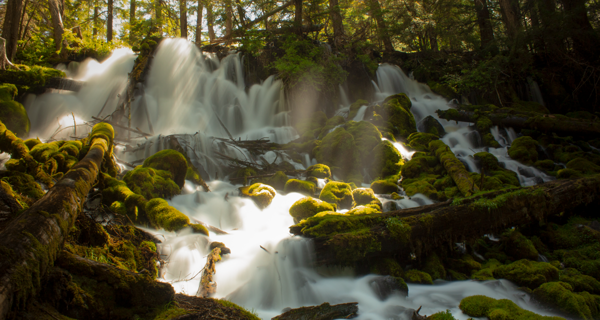
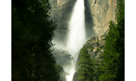
Clearwater Falls is a spring fed waterfall of approximately thirty feet in height accessiable by a very short trail. This waterfall is unique in that the river for these falls is rather unimpressive. The porous volcanic rock above and below the falls allows ample amounts of water to flow beneath through the ground. The falls appear as copious amounts of water drain from the river through the volcanic rock.
Clearwater Falls Camping Information
This waterfall is a great area to camp. A total of nine campsites are available with picnic talbes and fire pits. The falls separate the campground into two separate areas. One camping area is located above the falls. There are also four separate picnic areas with their own fire pits. Three vault toilets are at the site. For full camping information please visit the Umpqua National Forest site.
On A Personal Note:
Cearwater Falls was my first encounter with one of the many waterfalls along Highway 138. The spring fed waterfall is evidenced by the lack of flow from the river both above and below the falls. In fact, at the bottom of the falls it appears there is a log jam as the flow of the river slows below the falls. I highly recommend stopping here.
Do you have any updates to the hiking trail or want to share your hike/pictures? Please leave a comment below.
- Overall Difficulty: 5%
- Overall Views: 100%
Clearwater Falls Trail Quick Facts:
- Max Elevation: 4,241 feet.
- Elevation Gain: 32 feet.
- Estimated Distance: 0.2 miles.
- My Actual Distance: 0.23 miles.
- Estimated Time: 15-30 minutes.
- My Time: 6 minutes moving; 11 minutes total.
Clearwater Falls Trail Directions:
Clearwater Falls Trail Pictures:
-
- Agus
-
- A view of the picnic area from the trail.
-
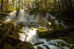
- A more, warming picture of the falls.
Who Clearwater Falls Trail Is For:
Advanced Hikers: Although, this is not a physically demanding hike, the waterfall is beautiful. I’d recommend this short trail for advanced or expert hikers strictly for the views.
Expert Hikers: Same. Expert hikers may enjoy using this camping area as a base for other hikes in the area.
It’s always a good idea to be aware of what type of hiking level you’re at.
Best Time Of Year To Hike Clearwater Falls:
Late spring to early summer is probably the best time of year to view these falls but specifically for weather reasons. Clearwater Falls is entirely springfed. The asthetics of the waterfall aren’t as dependent on current rainfall/snowfall in order to flow. Spring and early summer is when new growth is abounding from the plants. During this time of year the forest looks a crisp green with bright green moss carpeting the forest floor. All that being said, don’t let the seasons stop you from visiting this waterfall.
It’s always a good idea to check the weather prior to hiking.