
Hiking Cedar Creek Falls Trail
Waterfalls are few and far between in San Diego County and any waterfalls that do exist also have a very short life. Winter rains fill the creeks and streams but by mid summer, most falls have all become a trickle. Over the years a few waterfalls have become quite popular among local residents and visiting hikers. The waterfall is fed by Cedar Creek which originates in the higher elevations on the southwestern flank of the small city of Julian. From there the more abundant mountain rainfall and occasional snowfall helps to fill the creek. The creek continues downslope where it eventually meets up with the San Diego River Gorge and eventually to the Pacific Ocean.
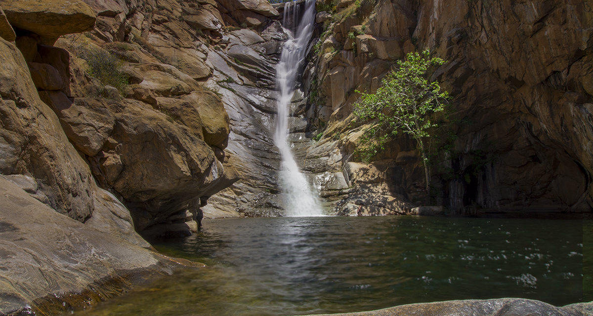
One of the additional attractions that brings visitors to this trail is the way that the waterfall has carved out a natural pond at the bottom over time. Locals have given the nickname of this swimming pond as Devil’s Punchbowl. The pond makes for an inviting place to swim, especially on warmer days once spring and summer set in.
There are two routes to get to Cedar Creek Falls. This trail guide focuses on the most popular route which begins in Ramona. There is another trailhead that begins in Julian from the Saddleback Mountain trailhead. Both trailheads require permits to go to Cedar Creek Falls. The trailheads also both involve an ascent to get out of the valley and to the beginning of the trial.
Cedar Creek Falls Disclaimer
Unfortunately, over the years the hike down into Cedar Creek Falls came with several caveats. For one, and quite honestly the most saddening part, is that several hikers have died at the waterfalls. Many factors went into this such as excessive alcohol consumption, people hitting their head at the bottom of the pond when jumping off rocks, or inexperienced hikers being unprepared for the elements and succumbing to heat stroke. All of these scenarios have happened multiple times.
Second, the trail became so popular that residents who live near the trailhead became increasingly frustrated over issues that had arose. Vandalism was occurring on a regular basis, noise complaints rolled in, and trash along the trail and at the waterfall was becoming a major problem. Local residents expressed their frustrations with the county.
As if this wasn’t enough, many hikers who entered the trail did so without being prepared for the heat or the hike up out of the valley. Many people would spend their time expending energy in the swimming pond leaving themselves too exhausted to get out of the valley. Others wouldn’t be carrying enough water or snacks which then left them dehydrated. These factors caused the county to persistently perform rescue operations along the trail. Rescues were involving anything from rattlesnake bites to heat stroke to falls.
In 2011 after the death of a sixteen year old who was found in the pond below the fall, officials had enough and closed access to the trail. Over a period that lasted about a year and a half, officials debated what should be done. The end result was a permitted hiking system based off a quota system. In the spring of 2013 the trails to the falls reopened.
How To Get Cedar Creek Falls Permits
The San Diego River Valley where Cedar Creek Falls sits lies within the Cleveland National Forest and is is the governing agency of this area. A permit to hike down into Cedar Creek Falls is required for both trail entrances. Permits can be obtained here. All permits are issued on a first come and first serve basis. Cost is six dollars. Seventy-five permits are issued per day and each permit is good for five people. When filling the permit out, it is important to include all hiker’s names as shown on their government issued identification. Permits and ID’s are regularly checked and this area is consistently patrolled.
Although the waterfall is on National Forest land parking to this trailhead lies out of their jurisdiction and therefore, an Adventure Pass or America The Beautiful Pass is not required. The Forest Service website states specifically that only printed permits are acceptable. However, I did see other hikers showing permits off of their phone. Use that information at your own discretion. Naturally, permits go quicker on the weekend.
Some things to keep in mind:
- There is no alcohol allowed.
- No campfires.
- Cliff areas above and around the falls are closed – therefore, no jumping or diving into the pond.
- Again, all people listed on the permit must carry a government issued photo ID.
Any violations are subject to a maximum fine of five thousand dollars or up to six months in prison.
On A Personal Note:
Despite the crowds, this is an iconic San Diego trail that should be done if you have the ability to do it. This area also brings with it the opportunity for viewing just about all of San Diego’s wildlife. Snakes are common during the warmer months, especially rattlesnakes. Because this trail is near a water source and in the foothills, larger wildlife like bobcats, deer, coyotes, and mountain lions could also be seen. This is a great trail for bird and wildflower viewing. I spotted a falcon soaring along the trail scouting for prey. Parking for the trailhead is at the edge of a residential community in Ramona so please be respectful to those who live there. Always practice Leave No Trace Principles.
Looking for a trail of similar caliber? Check out the Three Sisters Falls trail. This hike of equal difficulty leads to a three tiered waterfall. A recreational permit or America The Beautiful pass is required.
Do you have any updates to the hiking trail or want to share your hike/pictures? Please leave a comment below.
- Overall Difficulty: 85%
- Overall Views: 100%
Cedar Creek Falls Trail Quick Facts:
- Elevation: 1814 feet.
- Elevation Gain/Loss: 1000 feet.
- Estimated Distance: 6.6 miles.
- My Actual Distance: 5.6 miles.
- Estimated Time: 3-5 hours.
- My Time: 2 hours 35 minutes moving; 3 and 23 minutes total.
Cedar Creek Falls Trail Directions:
Cedar Creek Falls Trail Pictures:
-
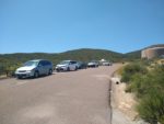
- Street parking at the trailhead.
-
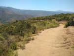
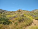
- Beginning the descent into the San Diego River Valley.
-
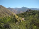
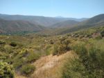
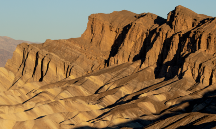
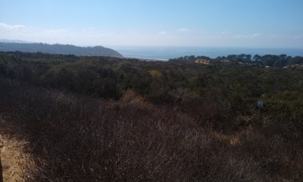
- Looking past the River Valley with the Cuyamaca Mountains in the middle distance.
-

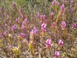
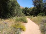
- Spring is a great time to view wildflowers along this trail.
-
- Looking to the south where the San Diego River leads to the coast.
-

- A look into the River Valley.
-
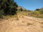
- At the bottom of the trail looking back up to where the trailhead is.
-
- Prior to the first river crossing – there is a trail that runs North to South through the river valley. Keep straight.
-
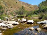
- The first San Diego River crossing.
-

- A constant reminder.
-
- Passing through the river valley with the trail lined Cottonwood and Oak trees.
-
- The second crossing.
-
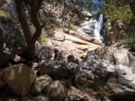
- Walking along Cedar Creek nearing with the waterfall peeking through the trees.
-
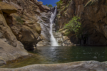
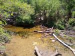
- The wonderfull waterfall pouring into Devil’s Punchbowl.
Who Cedar Creek Falls Trail Is For:
Advanced Hikers: This trail is a wonderful hike for advanced hikers.
Expert Hikers: Experienced hikers will probably get the itch to explore some of the other trails that wander through the San Diego River Valley. Nonetheless, this is a wonderful hike to check off the list of iconic San Diego trails.
Same. It’s always a good idea to be aware of what type of hiking level you’re at.
Best Time Of Year To Hike Cedar Creek Falls:
The hike down to Cedar Creek Falls can have very hot temperatures. I’ve been clear throughout this trail guide about the many stories of rescues from hikers being in over their head here. There are also multiple reported deaths from along this trail. The trailhead in Ramona is usually several degrees cooler than the river valley below where heat gets trapped. It is not uncommon for temperatures to be fifteen degrees warmer in the valley and well over one hundred.
If the trail is ever closed, check your email the morning of your hike. I had permits during the late winter but the Forest Service closed the trail because of excessive flooding from a series of passing storms. It’s also not uncommon for the trail to be closed for periods of time during the summer because of excessive heat.
Always remember to check the weather before heading out on a hike.
Cedar Creek Falls Trail Conditions:
Cedar Creek Falls is a very straight forward out and back trail. From the beginning, the trail winds down into the San Diego River valley. In about two and a half miles there is a one thousand foot elevation loss. Keep this in mind that there will be a thousand foot elevation gain waiting after seeing the waterfall.