
Hiking Rainbow Ridge Trail in Haleakala National Park
No trip to Maui is complete without visiting Haleakala National Park. Rising 10,023 feet above the ocean, the dormant volcano rises above sea level and composes the bulk of the land mass on Maui. The national park sits atop the summit and extends down a narrow sliver of the mountain to the eastern flank. There are two distinct districts within the park: the Kipahulu and Summit district. The Kipahulu district lies on Maui’s more remote eastern side of the mountain. This district features usually rough coastal areas and lush tropical slopes with waterfalls. The summit district encompasses all activities near the top of Haleakala which is the district where this trail is located.
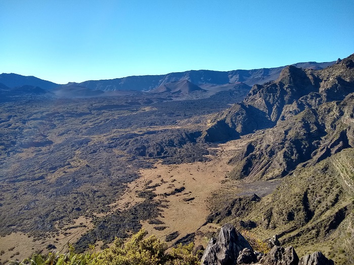
The rainbow bridge trail is a short out and back trail that leads to a natural land bridge. The bridge provides amazing viewpoints of the massive Haleakala crater that sits deep within its summit. Looking down towards the coast will be expansive views of the Ko’olau gap. The Ko’olau gap is a large valley over two thousand feet deep that extends down the eastern flank of Haleakala. This large gap was likely formed when a portion of the mountain slid off its base and down towards the coast. Today the gap is covered in lush forests and old lava flows towards the summit.
Although this is actually named the rainbow bridge trail it lies along the path of another hike. The bridge is along the Halemau’u trail which is a 7.6 mile out and back trail that descends the walls of Haleakala Crater into the bottom. The rainbow bridge is about 1.1 miles into the Halemau’u trail.
HALEAKALA HISTORY
In Hawaiian, Haleakala means, house of sun, which references the Hawaiian deity, Maui. According to Hawaiian culture, Maui wrestled with the sun at the top of this volcano. The legend starts after Maui’s mother complained that there wasn’t enough light during the day to complete all her tasks. Maui took to the top of Haleakala and captured the sun with a hook and fishing line and secured him to a tree. The sun begged to be released but Maui would only do so if the sun promised to move more slowly across the sky and provide more daylight.
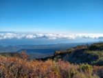
Legends aside, it’s the views from the summit of Haleakala that attract so many people. The pristine air is often clear, and to be honest, sunsets can be just as beautiful as sunrises from this location. However, sunsets are more often obscured by cloudy afternoons in the tropics. From the top of the mountain there will be 360-degree views. To the east, the mountains of Mauna Kea, Mauna Loa, and Hualalai on The Big Island will be visible. From sea level, Mauna Loa is also actually the tallest mountain in the world. To the west will lie the islands of Kaho’olawe, Lanai, and Molokai’i. To the east white fluffy clouds will line the horizon as the Pacific Ocean stretches out as far as the eye can see. As the sun rises it quickly paints the neighboring mountains and red volcanic craters of Haleakala in beautiful saturated colors. All while, the nearly eleven foot thousand mountain casts its shadow below.
On A Personal Note:
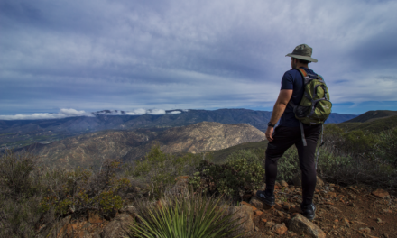
This is a short trail but the view packs quite a punch. My wife and I hiked this trail shortly after watching the sunrise. The views of Haleakala Crater and the Ko’olau Gap were amazing. On a clear day you can see the red and black colors of old lava flows meet the lush tropical jungle and see all the way to the coast. The morning temperatures were quite cool when we started but by the time we were heading back up to the parking lot it had warmed up.
Looking for something else to do nearby? Check out the sunrise from the peak of Haleakala. Witnessing the sun come up over the Pacific Ocean is an unforgettable experience. The towering 13,000 foot volcanos on the Big Island can also be seen.
Sources:
1. N.a. “Volcano Watch – Haleakala Crater formed between 145,000 and 120,000 years ago.” U.S. Geological Service. U.S. Department of The Interior. Volcano Watch — Haleakalā Crater formed between 145,000 and 120,000 years ago (usgs.gov). 11 March 2001. Accessed 9 June 2021.
- Overall Difficulty 30%
- Overall Views 100%
Rainbow Bridge Trail Quick Facts:
- Max elevation: 8,046 feet
- Elevation Gain: 712 Feet
- Estimated Distance: 2.4 miles
- My Actual Distance: 2.4 miles.
- Estimated Time: 1 hour.
- My Time: 59 minutes moving; 1 hour 14 minutes total.
Rainbow Bridge Trail Directions:
Rainbow Bridge Trail Pictures:
-

- Easily marked trailhead.
-

- Leading away from the parking lot as the trail begins.
-
- Further along the trail looking back up towards the parking lot.
-
- Most of the view looking to the north will be of the north eastern flank of the island.
-
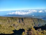
- Looking down below along the ridge of the Ko’olau Gap.
-

- As the trail leads to the edge of the crater it begins to hug the walls of the ridge.
-
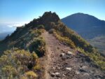
- The narrow rainbow bridge. To the left will be stunning views of Haleakala Crater and to the right will be the very large, Ko’olau Gap.
-
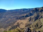
- Looking out towards Haleakala Crater.
Who The Rainbow Bridge Hike Is For:
Novice Hikers: This is a great trail for new hikers or those looking for a short trail to add to their park itinerary. Those who are higher on the acrophobic sensitivity scale may have some difficulty with the natural bridge as it is fairly narrow.
Advanced Hikers: For hikers that fall into this category this is an easy hike. It’s a great trail to do if you’re looking for several things to do within the summit district. For those with more time I recommend completing the complete Halemau’u trail.
Expert Hikers: Expert hikers will enjoy the complete Halemau’u trail. There is a cabin in the crater that can be reserved for overnights. The Halemau’u trail also connects to other hikes within the crater.
It’s always a good idea to be aware of what type of hiking level you’re at.
Best Time Of Year To Hike The Rainbow Bridge Trail:
Generally speaking there are narrow temperature variances throughout the year. However, given that this elevation is around eight thousand feet, it’s not uncommon to see sub-alpine conditions. Weather can be unpredictable at this elevation. At times the weather can be windy, rainy, foggy, warm one minute and cold the next. During the winter low pressure systems can actually lower the snow level and a rare snow event is not out of the question at this elevations. Do know that a snow event is very rare. Most of the time the weather will be just fine.
It’s always a great idea to check the weather before a hike.
Rainbow Bridge Trail Conditions:
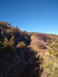
The Rainbow Ridge is about 1.1 miles into the Halemau’u hike. The trail is in good condition and managed by the National Park Service. As the trail begins it winds down a gentle slope which eventually leads to a ridge above the Haleakala Crater and Ko’olau Gap. As you get to the rainbow ridge the trail will wind through native shrubbery. By the time rainbow ridge approaches it’s mostly open and exposed. There is no shade along the trail. The trial is made of mostly a mixture off igneous and decomposed igneous rock. Watch your balance as you approach the bridge to not lose your step and fall down the crater several hundred feet.
If you’re ambitious, continue on to complete the rest of the Halemau’u trail hike. If not, enjoy the views of the crater, Ko’olau Gap, and the northeast flank of Maui and return to the trailhead. All the elevation gain will be done on the way back to the parking lot.