
Hiking Mount Baldy (San Antonio) Peak
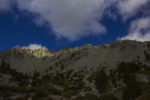
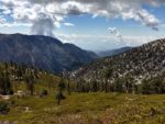
For Southern California hikers looking to take their hiking game to the next level, the trail leading up to Mount Baldy is a must. There are a few different routes to get up the peak. For the sake of this article I’ll be talking about the loop trail that begins at the Manker Flat Campground. This moderately trafficked trail offers incredible views of the deserts to the east, cities and the ocean to the west, and the rest of the tallest mountain ranges in Southern California. Hiking this trail is a great way to view sub-alpine environments close to home. Mount Baldy also gives people the chance to see wildlife like cougars, black bears, bighorn sheep, and deer.
The real name for Mount Baldy is actually Mount San Antonio. The name was given to the mountain by a local rancher who named it after Saint Anthony of Padua who lived during the thirteenth century. However, the appearance of the peak from the City of Los Angeles is bare and essentially, bald. Therefore, locals nicknamed the peak Mount Baldy. The name has stuck despite its actual name.
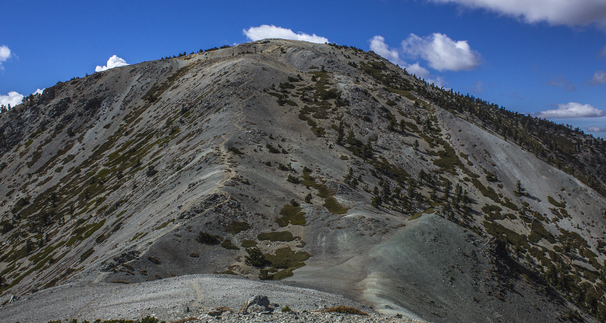
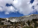
In addition to the opportunities for spotting wildlife, the peak can be a winter playground and is often topped with snow and/or ice during the winter months. During the spring and summer a multitude of wildflowers can be found along the lower elevations. As the elevation climbs, the landscape is covered in conifer pine forests. Near the peaks wind twisted pine and manzanita line the landscape before the peak turns into barren shale, sub-alpine surface.
Mount Baldy Ski Hut
During the winter, the peak is often covered in snow. There is a ski resort on the southeast side of the mountain and also a ski hut on the south slope. The ski hut sits at 8,300 feet elevation along this trail. It has a fully equipped kitchen, dishes, cookware, running water, and solar lighting. There is enough sleeping room for sixteen people. Some people use this as a camping site or to break up the hike to not do all ten plus miles in one day. This hut is quite popular, but if you want to consider staying here, check with the Sierra Club who operates this hut for more information.
On A Personal Note:
The ski resort operates lifts throughout the year and can cut about 2,000 feet of elevation gain off the hike. However, some people consider taking the ski lift up as cheating. This trail is a loop trail and many sites recommend hiking this loop counter-clockwise. Hiking counter clockwise will take you up the access road to the ski resort and lead you across the Devil’s Backbone up to the peak. Hiking this way is a longer way up but a steadier elevation gain.
I hiked this trail clockwise. Hiking Mount Baldy in a clockwise fashion is a shorter way up to the peak and takes you passed the ski hut and by the Baldy Bowl first. The trail will then lead across the Devil’s Backbone and down to the ski lifts. If you’d like you can take the ski lifts down from here.
Have you hiked this trail recently? Please updates and/or pictures in the comments section below.
- Overall Difficulty: 90%
- Overall Views: 100%
Mount Baldy via Manker Flat Trail Quick Facts:
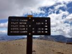
- Elevation: 10,064 feet.
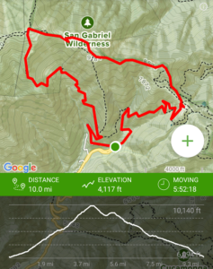
- Elevation Gain: 4,117 feet.
- Estimated Distance: 9.2 miles.
- My Actual Distance: 10.0 miles.
- Estimated Time: 6-8 hours.
- My Time: 5 hours 52 minutes (moving), 7 hours 16 minutes total.
Mount Baldy via Manker Flat Trail Directions:
If you decide to do the hike counter-clockwise, you can park in the parking lot for the ski lift. I hiked this trail when there was no snow on the summit in the fall. In the winter after storms, the parking lot can get full. Visitors come to the mountain for the snow and to also view San Antonio Falls. Therefore, the earlier the better to find parking.
Mount Baldy Peak Pictures:
-
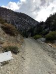
- Starting out from the bottom of the Manker Flat’s headed up to Mount Baldy. Much on the trail is flat on a old solid road on the way up to the ski hut.
-
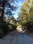
- The first mile or so of the trail is paved on a access road.
-
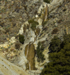
- San Antonio Falls – a nice treat on the way up. With the exception of the winter months, this waterfall is seasonal at best. This was captured in October before any rains/snow.
-
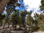
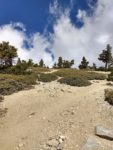
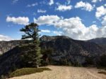
- A typical view of the conifer forests heading to the top of Mount Baldy.
-
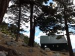
- The San Antionio Ski Hut is a great place to stop and take a rest before continuing on to the top.
-
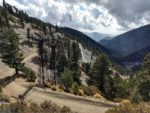
- A look of the Baldy Bowl from the Ski Hut.
-
- More of the Baldy Bowl.
-

- The Baldy Bowl.
-
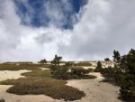
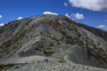
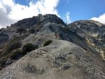
- After the ski hut the conifer forests gives way to this sub-alpine type of terrain.
-
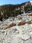
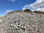
- Along the final push to the top, much of the trail becomes mysterious. Try to find the most established trail and follow it to the top.
-
- There are multiple trails; to prevent erosion, try to find the most used trail.
-
- A look down to the valley where the trailhead is.
-
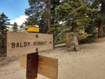
- Finally at the top.
-
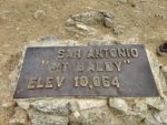
- The iconic San Antonio/Mount Baldy sign.
-
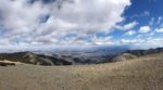
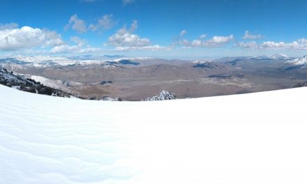
- Views from the top.
-
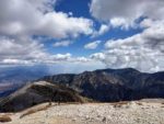
- Views looking to the east.
-
- Views looking to the West.
-

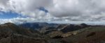
- More views of the Northeast from near Mount Harwood.
-
- A shot of the peak of Mount Baldy. This is what the trail would look like ascending from the opposite end.
-
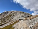
- Headed up to Mount Harwood peak.
-
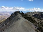
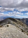
- A look along the well-known Devil’s Backbone portion of the Mount Baldy trail.
-
- A portion of the Devil’s Backbone trail.
-
- The road down to the bottom of the trailhead. If you’d like to cheat, you can take the ski lift down when it’s operating.
Who Mount Baldy Peak Is For:
Advanced Hikers: This is a great hike for advanced hikers. This trail will set you apart from other hikers and give you the bragging rights that you’ve hiked the highest peak in Los Angeles County. This trail is by no means easy, but you will feel good about completing the hike and experiencing the views on the top. If there is ice or snow on the top of the peak, I would not attempt this trail without crampons or an ice axe and some mountaineering experience.
If this is your first time hiking this high of altitude, make sure you’re hiking with a partner just in cause of altitude problems. People have died on this trail so use caution.
Expert Hikers: Mount Baldy is a perfect hike to give expert hikers the thrill they’re looking for.
It’s always a good idea to be aware of what type of hiking level you’re at.
Best Time Of Year To Hike Mount Mount Baldy:
Summers can be mild but have its warm days. Thunderstorms can be common. If there is a threat of lightning, don’t even attempt this hike. Monsoonal moisture in the summer can cause storms to pop up out of nowhere.
Fall and late spring days as the weather transitions are probably the nicest days. Winter can be beautiful but snowy conditions and ice can make this trail treacherous. Storm systems passing west to east along the jet stream to the north can bring very cold and very windy conditions at the top. Use common sense when hiking this trail and prepare accordingly. Layers are wise. It can be below freezing at the top and comfortable where the hike starts.
Mount Baldy via Manker Flat Trail Conditions:
You can start the trail in a clockwise or counter-clockwise fashion. I recommend doing the trail in a clockwise way. It’s steeper but a shorter distance to the top. The other way will be longer and a more gradual elevation gain along the loop. Taking the trail counter-clockwise will take you up near the ski-lifts. Whichever direction you start, they both start on service roads. The service roads eventually give way to shake dirt paths. As you get to the top the trail is made up of of both dirt and very small rocks.
The Devil’s Backbone Trail
On the eastern edge of Mount Baldy there is a well-known ridge called the Devil’s Backbone. Counter-clockwise you’ll need to cross it before the peak. The opposite direction will have you come down along the Devil’s Backbone trail. This portion of the trail is a narrow ridge that leads down from Mount Baldy to the Ski Resort. People need to use caution when crossing this portion of the trail. A slip and fall could easily result in falling off the edge of the mountain and end horribly. If there is ice or snow here, only cross this portion of the trail with proper winter equipment. In fact, people have fallen and died while crossing the Devil’s Backbone.
I do think the name is worse than it sounds. This part of the trail could give people who have vertigo or fear of heights some problem. Just be careful.
The Baldy Bowl
On the southern face of the mountain, there is a bald face of the mountain for which the “Baldy” name comes from. You’ll be able to see this from the portion of the trail that crosses the bottom of the trail near the ski hut. Some of the bald face is littered with incredibly large moonscape looking rocks leftover from a large landslide. Starting clockwise, you’ll be coming up across the Baldy Bowl.
Mount San Antonio Falls
Also on the southern side of the mountain is the notorious San Antonio Falls. During the winter months after rainstorms or with melting snow, the falls can plummet near 80 feet. Hiking from a clock-wise fashion, the falls will be about 1.2 miles in prior to reaching the ski hut.
Summing Up The Mount Baldy Hike
Mount Baldy is a truly beautiful hike. If you’re physically capable, I highly recommend this entire trail. There are so many picturesque views along the trail. The panoramic views at the top of the peak are breathtaking. As a reminder, rattlesnakes can commonly be seen along portions of this trail. Poison oak will probably only be seen on the lower portions of the trail but highly unlikely.