

Glacier Point Hiking Trail Guide
Of all the incredible places to experience in Yosemite National Park it’s nearly impossible to pick just one. I would imagine Glacier Point is probably one place that ends up on a lot of people’s top five list if not their favorite view of Yosemite National Park. This hike is a short and commercialized out and back trail that leads to the edges of the southern walls of Yosemite Valley. The big feature here is a large a large hanging slab of granite that extends several feet away from the edge of the granite wall. The overextended granite peers straight down a few thousand feet into the depths of Yosemite Valley at some of Yosemite’s most iconic landmarks.
In addition to the expansive views, Glacier point also has quite a bit of historical relevance to the valley as well. The popular Four Mile Trail exists as part of an old road that led up the valley floor to a now vanished hotel at Glacier Point. Dumping of hot coals from firepits at the hotel over the edge of Glacier Point gave the appearance of a fiery waterfall at night. This led to a long tradition known of as the Firefall where visitors would annually dump hot embers over the edge of glacier point. The tradition has been discontinued (1).
Another significance of Glacier Point is the famous picture that John Muir took with President Roosevelt in 1903. At the time Muir penned an open letter to the President inviting him to spend some time in the park. Roosevelt took up Muir on the offer and spent some time camping in the area. The President’s experiences in Yosemite and conversations with Muir helped lead to the creation and conservation of Yosemite as a National Park (2).
One A Personal Note:
Glacier Point is a must for those visiting Yosemite National Park. This area offers some of the best panoramic views of Yosemite Valley and it’s higher elevations. It’s a great way to view some of the large granite domes formed by molten bubbles of magma millions of years ago. Some of the views that people can frequently see from this area are the back end of Yosemite Valley, Yosemite Falls, Half Dome, North Dome, Cloud’s Rest, Little Yosemite Valley carved out by the Merced River, Vernal and Nevada Falls, and many peaks of interest in Yosemite’s higher elevations. Glacier Point is also an excellent place away from the lights of the valley to stargaze with an open sky.
I highly recommend coming to the area during the late spring and early summer. At this time of year the higher elevations will be capped with snow and the waterfalls in the valley below will be roaring. Keep in mind that the road to Glacier Point closes after the first major snowfall in the fall/winter and won’t reopen until plowing is completed in the spring.
Looking for something similar nearby? Stop by Washburn Point right before Glacier Point on the same road. This viewing point offers equally impressive views of Half Dome but better views of Yosemite’s backcountry to the south and a more direct view of Nevada and Vernal falls. If you’re looking for something more difficult, try the trail to Sentinel Dome. This short hike offers what in my opinion are the best views in the entire park. If you’re looking for a more direct view of Yosemite Falls, consider the hike down to Union Point. This viewing point is about 3.7 miles from Glacier Point along the Four Mile trail and offers a direct view of Yosemite Falls and a panoramic view of Yosemite Valley, including El Capitan.
Sources:
1. N.a. “Historic Ashes: Glacier Point Hotel 1969.” Yosemite National Park. National Park Service. https://www.nps.gov/articles/historic-ashes-glacier-point-hotel-1969.htm. 2 December 2016. Accessed 10 August 2021.
2. N.a. “Muir’s Influences.” Yosemite National park. National park Service. https://www.nps.gov/yose/learn/historyculture/muir-influences.htm. 1 March 2015. Accessed 10 August 2021.
Do you have any updates to the hiking trail or want to share your hike/pictures? Please leave a comment below.
- Overall Difficulty: 10%
- Overall Views: 100%
Glacier PointTrail Quick Facts:
- Elevation: 7,200 feet.
- Elevation Gain: 50 feet.
- Estimated Distance: 0.6 miles.
- Estimated Time: 15-30 minutes.
Glacier Point Trail Directions:
Open in maps. Cost is admission to Yosemite National Park. An America The Beautiful pass will also work. Access to the trailhead is very easy. This trailhead is at the end of Glacier Point Road. You will know it when you get there. There is a large parking lot with ample parking. During the winters this road is closed due to heavy snowfall. Glacier Point Road does tend to open up earlier in the year than Tioga Pass. Please check with the park on the current road conditions if you plan on traveling when there may be snowfall. There is no cell phone service in this area so know where you’re headed before you head deeper into the park.
Glacier Point Trail Pictures:
-
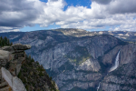
- Glacier point itself with Yosemite Falls as a splendid backdrop.
-
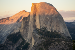
- A Half Dome sunset seen from Glacier Point.
-
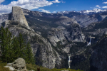
- A panoramic view of Yosemite’s most iconic sights as seen from Glacier Point.
Who Glacier Point Trail Is For:
Advanced Hikers: For advanced hikers, I recommend using Glacier Point as a viewing point and doing one of the other many short hikes close by. Taft Point and Sentinel Dome would be great pairing options.
Expert Hikers: If you are up for some adventure, consider reaching Glacier Point via the Four Mile Trail. The sense of accomplishment and views experienced along the way will be worth far more than the drive.
It’s always a good idea to be aware of what type of hiking level you’re at.
Best Time Of Year To Hike Glacier Point:
The best time of year for most people to hike Glacier Point is going to be after the road has opened from being plowed from the winter snowpack. For those looking to get to Glacier Point other times of the year it will require a higher level of fitness and spirit of adventure. If the Four Mile Trail is open in its entirety Glacier Point can be accessed via a nine mile round-trip hike from Yosemite Valley. The other option would be snowshoeing from the Yosemite Snow and Ski Area. But I say why bother with all of that stuff when there are many sights to explore off of Glacier Point road anyway. Besides, once the road is open in the late spring Yosemite, Nevada, and Vernal falls will be at their most impressive stage.
Always be prepared by checking the weather conditions before a hike.
Glacier Point Trail Directions:
This trail is in great condition and is maintained by the National Park Service. The trail begins right at the parking lot and rises slightly on a paved pathway to glacier point. While there take a little time to checkout one of the several informational placards at the site. The odds of seeing a rattlesnakes along this trail are close to zero given the commercialization of the area. There will be an opportunity to see bears and deer here. There is no poison oak along the trail.