

Heart Rock Trail Guide – Joshua Tree National Park
For those who have spent time within Joshua Tree National Park, you’ll know there is no shortage of names for rock formations that resemble common objects. Skull Rock, Elephant Rock, and Mastodon Peak are a few examples. Heart Rock is no different. The highlight of this trail is a large life size and vertical standing rock in the shape of a heart. The trail to heart rock is usually hiked in conjunction with the Arch Rock Trail which shares the same parking lot. Heart Rock is a popular landmark but it is unlisted by the National Park Service and there is no official marked trail to get there. For specific directions please see the directions tab.
On A Personal Note:
I found Heart Rock to be a very neat landmark. The trail begins at the same place as the trail for Arch Rock which is a very popular geological landmark in Joshua Tree National Park. Arch Rock is a wind formed granite arch and I highly recommend it for anyone who is visiting the park. My wife and I actually couldn’t find Heart Rock the very first time we tried on a previous visit. We had read to walk straight past Arch Rock for a couple of hundred yards and the heart shaped rock would be obvious. Well, we failed. This time around we had a specific location set in our GPS and were able to find it. I highly recommend using the provided coordinates in the directions tab to locate Heart Rock as well.
In the last few years, it seems that Joshua Tree National Park has only appeared to get busier, especially since Covid. There are two parking lots for the Arch Rock trailhead: White Tank Campground and the parking lot for Twin Tanks. White Tank Campground parking is very small but the trail is shorter. Twin Tanks is longer but we found it easier to find Heart Rock from this trailhead because the trail naturally continues straight past the right fork for Arch Rock. There is no marked trail for Heart Rock so try to use the established use trail that is pretty obvious. Staying on an established trail helps to prevent further soil disruption and plant destruction.
Looking for some other things to do? Visit the day guide to Joshua Tree National Park. For those looking for similar type hikes in the park, check out the Barker Dam Loop Trail or Mastodon Peak Hiking Trail Guide. As a reminder, expect on there being no cell phone service within the park. Plan your itinerary ahead of time or rely on the park map.
Visited this trail recently? Post a comment in the section below to provide an update.
- Overall Difficulty: 30%
- Overall Views: 85%
Heart Rock Trail Quick Facts:
- Max Elevation: 3,911 feet.
- Elevation Gain: 108 feet.
- Estimated Distance: 1.7 miles.
- My Actual Distance: 1.7 miles.
- Estimated Time: 60-90 minutes.
- My Time: 48 minutes moving; 1 hour 7 minutes total.
Heart Rock Trail Directions:
As mentioned, there are two primary parking lots to access the main trailheads for Heart Rock: White Tank Campground (open in maps) or the lot for Twin Tanks/Arch Rock Trailhead (open in maps). White Tank Campground is the shorter option by far. However, you’re competing with a camp site, a very small parking lot, and a vault toilet that gets a lot of through traffic. Twin Tanks is nearby with a larger lot but the distance is longer. Cell phone service is poor within the park so it’s likely you’ll have to use a park map. Cost is the price of admission to the park. An America The Beautiful Pass will also work. I highly recommend putting in these coordinates to locate heart rock (open in maps): 33.59173 N and 116.00483 W.
Heart Rock Trail Pictures:
-
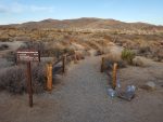
- The start of the trail from the Twin Tanks/Arch Rock parking lot.
-

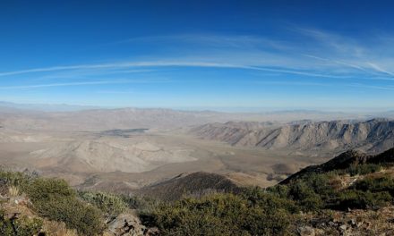
- Along the trail looking towards the south onward towards White Tank Campground and Arch Rock.
-

- Looking towards the south along the trail back to the parking lot.
-

- There is little elevation gain along this trail. There is a small incline over some granite rocks before reaching Heart Rock.
-

- Heart Rock during sunset; looking towards the east.
Who Heart Rock Trail Is For:
Novice Hikers: This is a great hike for new hikers or for those who aren’t used to hiking long distances. For an extra 0.3 mile added to your hike, I suggest including Arch Rock along with this route.
Advanced Hikers: This isn’t a difficult trail of any sort. Hiking out to Heart Rock is a unique experience and a great place to photograph.
Expert Hikers: If you’re looking for challenges when it comes to hikes, include some other nearby hikes to add some distance.
It’s always a good idea to be aware of what type of hiking level you’re at.
Best Time Of Year To Hike Heart Rock:
This is the desert so expect high heat during the summer and wide temperature swings during the winter. Late winter and early spring is without a doubt the best time to hike this trail. Years with higher than normal rainfall will also bring an abundance of vibrant colors of blooming cactus, Joshua Trees, and wildflowers. May usually ushers in hot temperatures and the hottest months are typically June and July with temperatures exceeding well over 100 degrees. Early fall can still have some very hot temperatures but the evenings and mornings tend to be a little cooler.
Summer can bring about other problems besides just heat. The summer months are the monsoon season for the desert. This season brings about the chance for lightning and thunderstorms. Avoid being out in the open during a thunderstorm to prevent being hit by lightning. The trail does not have any low lying areas so there should be no concern of flash flooding here.
It’s always a good idea to check the weather before heading out on a hike.
Heart Rock Trail Directions:
This trail is in good condition and maintained by the National Park Service. At times after severe thunderstorms the trail can become washed out but that’s more of a rarity. There are two different ways to reach Heart Rock. As I mentioned previously, I highly suggest using the coordinates provided in the directions tab to pinpoint exactly where Heart Rock is. Heart Rock is not an official landmark noted by the NPS and is found east north-east of Arch Rock.The trail gets a lot of foot traffic but still keep an eye out for rattlesnakes.
Heart Rock From The Twin Tanks/Arch Rock Lot
Head due south along a clearly marked trail for Arch Rock. After a short 0.1 mile stroll the trail will fork to the left and cross Pinto Basin Road. Use caution here as there is quite a bit of traffic through this area. Continue east for 0.4 miles. At this point there will be a fork in the trail to the right which will lead to Arch Rock. If you look straight ahead you will notice an obvious use trail that will continue towards the east. Follow this trail for approximately 0.2 miles and you will end up at Heart Rock.
Heart Rock From White Tank Campground
If you’re able to score a parking spot at the small lot at White Tank Campground you’re in luck for a much shorter hike. Here there is a very clearly marked trail that leads to Arch Rock. Follow the trail to Arch Rock which won’t be longer than 0.2 miles. The tricky part is connecting with the trail that comes in from the Twin Tanks lot. This trail is on the west side of Arch Rock and to the north by about twenty yards. Once you connect with this trail head east on the established use trail to Heart Rock. Use the coordinates provided. My wife and I couldn’t find Heart Rock from this route and had a much easier time finding it from the Twin Tanks lot.

