Pfeiffer Beach Hiking Trail Guide
When one thinks of Big Sur the images that often come to mind are deep canyons, mountain peaks, and a rugged coastline. The Santa Lucia Mountains run through most of the seventy plus mile stretch that makes up this coast line. In some cases the mountains extend a few thousand feet into the Pacific Ocean below. Taking a closer look however the coastline is scattered with beautiful beaches along the way.
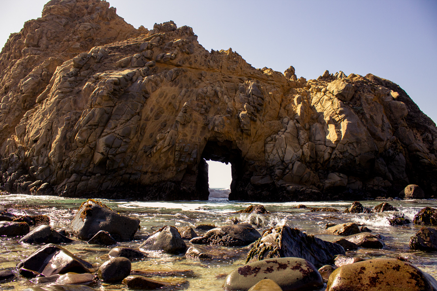
Pfeiffer Beach is a small beach tucked away in the canyons in the heart of Big Sur. The trail is a simple out and back trail. One of the draws to this beach is the beautiful white sand with purple hues. The purple sand is from minerals that are washed down from rains in the nearby mountains. Another big draw to the beach is the key hole rocks that sit right off the shore. These rocks have a carved out hole from the ocean currents and are a popular photography subject.
The beach is named after one of the first prominent European families to settle the area: Michael and Barbara Pfeiffer. This family had a homestead and a large plot of land higher up in the mountains that eventually became part of Pfeiffer Big Sur State Park. Despite the name, the beach has no affiliation to the state park. Pfeiffer Beach falls under Los Padres National Forest management.
Swimming At Pfeiffer Beach
Several websites mention that swimming at Pfeiffer Beach can be dangerous due to the currents. Pfeiffer Beach is actually a great place to swim it just depends on the time of year. The highest risk for strong currents is between mid-fall and early summer when the storm track sends larger size swells towards this part of the California Coast. During this time large waves and strong currents can inundate the beaches. Summer and fall can be quite pleasant. Obviously, use your own discretion and if the waves look larger than you can handle, stay out of the water. Also be aware of the large rocks that line the shoreline. Sometimes waves and/or strong currents may pull people close to them.
On A Personal Note:
If you have the chance, I highly recommend visiting this beach. From the memory I have, I thought the purple hues were a bit exaggerated from what I’ve read online. I was more impressed with the white sand and light blue water. Equally as impressive was the giant key hole rock. Photography enthusiasts will delight at this natural rock formation. Two times a year the sun can actually be seen setting through the key hole.Have you hiked this trail recently? Please share any trail updates/pictures in the comments below.
- Overall Difficulty: 15%
- Overall Views: 100%
Pfeiffer Beach Trail Quick Facts:
- Max Elevation: 19 feet.
- Elevation Gain: 19 feet.
- Estimated Distance: 0.9 miles.
- My Actual Distance:0.4 miles.
- Estimated Time: 10-20 minutes.
Pfeiffer Beach Trail Directions:
Sycamore Canyon road is in a residential area, so please keep that in mind while traveling along the road. This road is gravel and very narrow. In some areas the road is only thin enough for one vehicle. Please drive with caution and keep your eyes out for approaching traffic. Where you have space, it is best to wait for an approaching vehicle to pass to prevent congestion along the road.
Although the beach is under Los Padres National Forest land an America The Beautiful pass will not be accepted here. A Parks Management Day Use Annual Pass is. To direct funds directly to care of the beach, there is a $12 access fee. I highly recommend cash vs. a credit card. The parking lot is very small and fills up quickly especially during weekends, summer months, and days with nice weather. If the parking lot is closed staff will not allow vehicular traffic to travel down Sycamore Canyon Road.
If you have an update to any process involved with Pfeiffer Beach access, please leave a comment in the section below.
Pfeiffer Beach Trail Pictures:
- The small narrow gravel road leading down to the beach.
- The small parking lot fills up quickly.
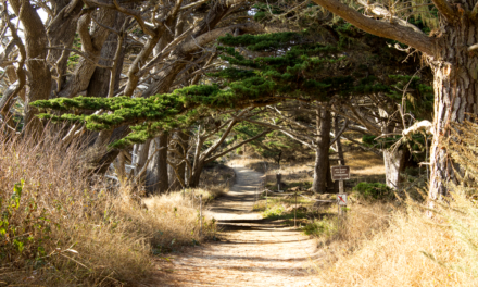
- Cyprus trees line the trail from the parking lot to the beach.
- This is a beautiful white sand beach.
- The key hole rock is a popular photography subject.
Who Pfeiffer Beach Trail Is For:
Novice Hikers: This is a great trail for new hikers. The trail is relatively flat. One doesn’t need to hike the entire span of the beach to enjoy its beauty.
Advanced Hikers: If you want to have a longer hike, take a stroll along the whole length of the beach. This is a short trail but the beauty of the beach is stunning.
Expert Hikers: Same. This is a good short trail with a rewarding view that can easily be paired with some shorter hikes in the area. One option would be Pfeiffer Big Sur State Park.
It’s always a good idea to be aware of what type of hiking level you’re at.
Best Time Of Year To Hike Pfeiffer Beach:
Generally speaking, there is not a bad time of year to take the short stroll down to Pfeiffer Beach. Late fall, winter, and through the spring are going to be the coldest times of year. However, in true California fashion, there can be warm beautiful days scattered throughout any of those months. During the late spring and early to mid-summer heavy fog can often blanket the coast until the sun burns the clouds off. I personally think fall is one of the best times to visit this area. Temperatures are warm and the skies are generally clear.
As for swimming, the California storm track generally starts swinging into gear around October. The storm track can keep sending swells to the region until mid-spring when it’s starts to taper off. Sometimes the northwest swells can last into the early summer. The swells can bring high surf and strong currents and make the water unsuitable for swimming. Late summer and early fall will likely be the warmest water temperature for swimming. All other times will be cool to cold.
It’s always a great idea to check the weather before a hike.

