
May Lake Hiking Trail Guide
In Yosemite National Park there is no shortage of short trails that lead to incredible views. If there was a list that kept track, May Lake would easily earn its spot. This short out and back hike leads to a small high elevation lake in Yosemite’s high country. The lake is mostly fed from the significant amount of snowmelt that occurs each spring.
May Lake sits nestled in along the eastern flank of Mount Hoffman. Mount Hoffman is one of Yosemite’s iconic peaks that can be seen from many places in the park including Lembert Dome and Glacier Point. To reach this lake the trail winds along the granite flank of Mount Hoffman. Along the way will be incredible and unique views of Clouds Rest and Half Dome.
The lake was named after Lucy Mayotta Browne. Browne was a future bride of Charles Fredrick Hoffman. Hoffman worked for the geologic survey team as a cartogropher. He was responsible for mapping out much of the Yosemite area between 1863-1867. In addition, Mount Hoffman at 10,772 feet was named after him as well.
On A Personal Note:
May Lake is an exceptional hike. The views of Clouds Rest and Half Dome on the way up are one of my favorite parts about the trail. This lake is one stop along the way up to Mount Hoffman as well as the High Sierra Trail. I’d imagine those that go on to complete those routes are greeted to some beautiful sights. Keep an eye out for the gargantuan sized marmots that make their home in the rocky flanks of Mount Hoffman.
Trail Tip: On the east facing side of the trail right before the campground there is a small ridge ridge line. If you step off trail to the tree line on top of the ridge there will be an amazing view of Tenaya Lake.
Looking for another short trail in Yosemite’s high country? Take a look at the small yet rewarding trail that leads up to Lembert Dome.
Sources:
1. N.a. “High Sierra Camps” Travel Yosemete. Aramark. https://www.travelyosemite.com/lodging/high-sierra-camps/. Accessed 9 September 2020.
2. N.a. High Sierra Loop. The Ansel Adams Gallery. https://www.anseladams.com/high-sierra-loop/. Accessed. 9 September 2020.
Do you have any updates to the hiking trail or want to share your hike/pictures? Please leave a comment below.
- Overall Difficulty: 55%
- Overall Views: 100%
May Lake Trail Quick Facts:
- Max Elevation: 9,388 feet.
- Elevation Gain: 495 feet.
- Estimated Distance: 2.8 miles.
- My Actual Distance: 2.8 miles.
- Estimated Time: 1.5-4 hours.
- My Time: 1 hour 26 minutes total; 1 hour 15 minutes moving.
May Lake Trail Directions:
While driving up May Lake Road enjoy the meadows created by Snow Creek. Snow Creek runs downhill from May Lake. The creek eventually meets the Merced River in Yosemite Valley. During the winters Tioga Pass Road is closed due to heavy snowfall. The road can close as early as October in some years and open as late as June. Please check with the park on the current road conditions if you plan on traveling when there may be snowfall.
May Lake Trail Pictures:
-
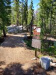
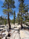
- The start of the trailhead.
-
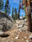
- Some of the granite steps lining the trail along the way.
-
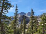
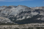
- Some of the first views of Mount Hoffman above the tree line.
-
- Most of the trail looks like this on the way up.
-
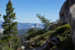
- Views of the west wall of Half Dome on the way up/down.
-
- There’s a great view of Tenaya Lake from the ridge line right above May Lake.
-
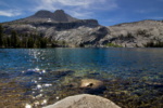
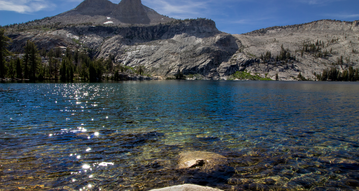
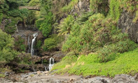
- May Lake in all its beauty with Mount Hoffman in the background.
Who May Lake Trail Is For:
Advanced Hikers: While not as challenging as some of Yosemite’s longer trails, this is certainly a fun trail to complete. The lakeside views complete the hike. Clouds Rest and Half Dome will be there to greet you on the way up and on the way down. For a longer and more challenging hike, think about doing Mount Hoffman. This also makes a great trail to do in additional to several other short hikes in the area.
Expert Hikers: My wife and I included this hike in one of the many stops that we did along Tioga Pass Road. Earlier in the day we completed the loop up to Lembert Dome. The views here are worth the short hike. Expert hikers looking for more difficulty should consider the full Mount Hoffman out and back hike. Another option is the High Sierra Loop. This hike will take several days and is over forty-five miles in length. May Lake is one of the campgrounds along the way.
It’s always a good idea to be aware of what type of hiking level you’re at.
Best Time Of Year To Hike May Lake:
It’s not uncommon for there to be thunderstorms in the higher elevations of the Sierra’s during summer. Thunderstorms often bring with them the threat of lightning. Do not attempt to be on the dome if there is any chance of lightning. It is a bare surface and you will be the tallest object and a target to be struck by lightning.
During the winter Tioga Road closes at around the first major snowstorms. The road doesn’t open again until late spring or early summer after the road has been plowed and cleared. Please check with the National Park Service for current road conditions around mid-fall or late spring.
The trail is scantly lined with towering conifers but shade is light. Prepare for near full sun and exposure to the elements along the trail.
Always be prepared by checking the weather conditions before a hike.
May Lake Trail Conditions:
The odds of seeing a rattlesnakes along this trail are pretty small given the high altitude and short growing season. However, always keep your eyes open and be alert. There will be an opportunity to see bears and deer here. Where the seasonal creek lies is the best bet for any wildflowers. Keep an eye out for the beautiful snowflower that likes to spring up near pines after the snow is gone. There is no poison oak along the trail.