
Fall Creek Falls Hiking Trail Guide
With almost one million acres of forest (983,129 to be exact), Umpqua National Forest is one place that doesn’t disappoint. The forest stretches from just north of Crater Lake National Park and spans to the western edges of the southern Cascade ranges. Within its boundaries are an abundance of culture, lakes, waterfalls, enchanting forests, and snow-capped volcanic domes.
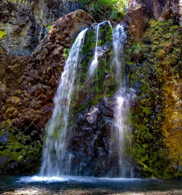
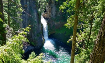
The trail leading to Fall Creek Falls is a short one mile out and back hike with rewarding views. The culmination point will be a two tiered waterfall. The tallest and upper portion of the waterfall measures thirty-five feet. The lower tier reaches fifty feet and is the most noteworthy. Viewers will be able to hike right up to the base of the falls when the flow is tranquil. The best place to view both tiers is from a short distance out on the left side of the creek or from above the shallow gorge.
Falle Creek is a short tributary that feeds into the North Umpqua River. The North Umpqua River eventually feeds into the Umpqua River and flows over one hundred miles in length to the Pacific Ocean. This river is a significant drainage source for the southwestern Cascade region. The surrounding vews along the hike will include a mix deciduous and conifer forest.
On A Personal Note:
This is another beautiful waterfall along this amazing stretch of highway. As the trail leads to the base of the waterfalls there is a set of switchbacks that lead up above the waterfall. This portion of the trail leads to a viewing platform where hikers can have a better view of the higher tier. From what I noticed, the majority of the people turned around at the base of the falls.
Looking for two other short waterfall hikes in the area? Try Toketee Falls or Whitehorse Falls. These two falls have short trails and even camping options.
Do you have any updates to the hiking trail or want to share your hike/pictures? Please leave a comment below.
Sources:
1. N.a. “Fall Creek Falls National Recreation Trail #1502.” Umpqua National Forest. United States Department of Agriculture Forest Service. https://www.fs.usda.gov/recarea/umpqua/recarea/?recid=63690. Accessed 1 August 2020.
2. N.a. “About The Forest.” Umpqua National Forest. United States Department of Agriculture Forest Service. https://www.fs.usda.gov/main/umpqua/about-forest. Accessed 1 June 2020.
- Overall Difficulty: 40%
- Overall Views: 100%
Fall Creek Falls Trail Quick Facts:
- Max Elevation: 1,353 feet.
- Elevation Gain: 295 feet.
- Estimated Distance: 1 mile.
- My Actual Distance: 1.29 miles.
- Estimated Time: 30-90 mintes.
- My Time: 25 minutes moving; 43 minutes total.
Fall Creek Falls Trail Directions:
Fall Creek Falls Trail Pictures:
-
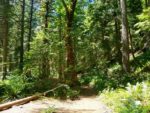
- Near the start of the trail by the parking lot.
-
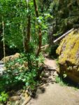
- Some arts of the trail are on the narrower side.
-
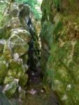
- Squeezing between the rocks at a certain point.
-

- There is plenty of poison oak along the trail. Avoid leaves of three.
-
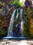
- The gentle tiered Fall Creek Falls.
Who Fall Creek Falls Trail Is For:
Advanced Hikers: This is a gradually inclining trail of ease with great views at the end. For a full day, group in some of the other short waterfall trails nearby.
Expert Hikers: Same as above.
It’s always a good idea to be aware of what type of hiking level you’re at.
Best Time Of Year To Hike Fall Creek Falls:
Late spring to early summer is probably the best time of year to view these falls not only for weather reasons but it’s also when the creek is at its highest levels. Spring and early summer is when new growth is abounding from the plants. All that being said, don’t let the seasons stop you from visiting this waterfall.
It’s always a good idea to check the weather prior to hiking.
Fall Creek Falls Trail Conditions:
There is plenty of poison oak along the trail. In some parts the poison oak grows right up to the trail’s edge. Keep your eyes open and know how to recognize the leaves of three. Keep an eye out for rattlesnakes during the warmer months.