
McArthur-Burney Falls Memorial State Park
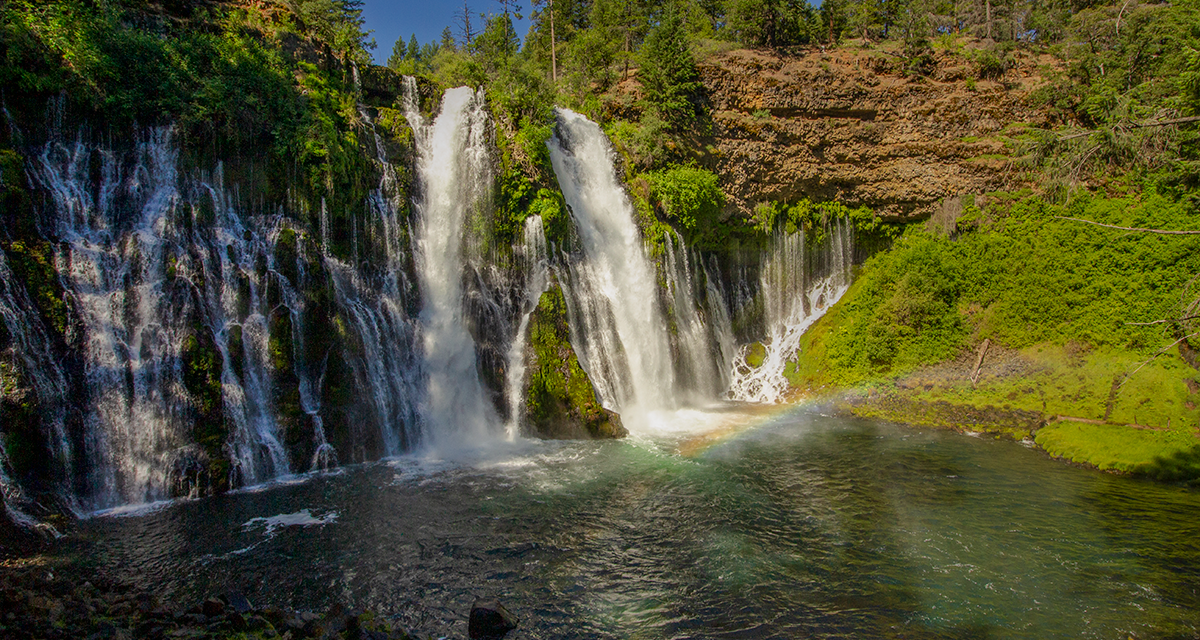
Located between the southern Cascade volcanoes of Lassen and Mount Shasta is the home to McArthur-Burney Falls Memorial State Park. This state park is the site of the well known, Burney Falls. This beautiful waterfall drops one hundred twenty nine feet from Burney Creek into a beautiful blue pond below.
Although Burney Falls isn’t the tallest waterfall in the state, some would argue that it is certainly the most beautiful. The land on which Burney Creek travels through is made up of 200,000 year old lava flows. As one looks towards the base of Burney Falls, some of the layers of of the cliff walls are from lava flows that date back 2.5 million years. The basalt lava rock is porous in nature. This sponge like rock gives the appearance that some of the falls are weeping down the cliffside out of the rock.
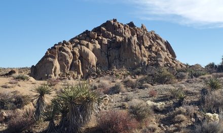
Even though the prizel of McArthu-Burney Falls Memorial State Park is the waterfall itself, there is much to be desired in the entire area. The famous PCT cuts a path straight through the park. Hikers can easily access the shores of nearby Lake Britton from the park. As the trails wander further from the falls, hikers can rejoice in the shade cast by thick conifer and oak forests. Away from the popular fall viewing area people may experience larger wildlife like bobcats, mule deer, mountain lions, porcupines, and coyotes. Bird viewing is a great option here. The cliffs of the falls are home to black swifts which nest along the cliffs. The swifts can be seen dodging in and out of the falls feeding on tiny freshwater shrimp.
McArthur-Burney Falls Memorial State Park History
Prior to western settlers coming to the area, the land surrounding the area was inhabited by the Pit River Tribe of Native Americans. These native people’s of California occupied the Pit River which drained the water basin of the southern Cascade Range. By the mid-1800’s European and American explorers began to settle the area. Unfortunately, individual bands of the original natives succumbed to disease or were forcibly displaced on to a reservation.
The park was initially named after two prominent settlers who resided in the area during the 1800’s: Samuel Burney and John and Catherine McArthur. The McArthur’s purchased thousands of acres of land throughout the area. In 1917, the expanding Pacific Gas and Electric (PG&E) company began buying up land and water rights in the throughout the water basin. Residents feared that PG&E would build hydroelectric dams along the Pit River and destroy Burney Falls in the process. In 1920, the sons of John and Catherine McArthur, purchased 160 acres of land surrounding the falls and deeded it to the State of California. Their only requests were that it be named for their parents.
Eventually the Pit River was dammed but Burney Creek and its waterfalls were spared. In 1926 the area became a state park now known as McArthur-Burney Falls State Park. The dam now forms the nearby Lake Britton Reservoir which is a large area worthy for exploring in itself. Lake Britton can be can be hiked to just a few miles away from Burney Falls or accessed via vehicle.
On A Personal Note:
Burney Falls was on my list of places to visit for as long as I had known it existed. The falls lived up to my expectations and more. The views of watching the streams and springs cascade down the cliffs of Burney Creek and through the porous rock were phenomenal. I have read that crowds can be a major factor here during the summer. My wife and I had arrived very early in the morning on a Friday in June. Crowds were very light and parking was plentiful but it had quickly filled up just a couple hours after sunrise. My best tip is to get there early and go during the week.
There are many recreational things to do within the state park including camping, boating, and fishing. Day use fees for the park are $10 for just regular visitation. Depending on the vehicle or if camping is involved, fees can increase. The park is open from sun up to sun down every day of the year. For more information, please visit the park’s website or call, (530)-335-2777.
Do you have any updates to the hiking trail or want to share your hike/pictures? Please leave a comment below.
- Overall Difficulty: 35%
- Overall Views: 100%
McArthur-Burney Falls Memorial State Park Quick Facts:
- Elevation: 2,981 feet.
- Elevation Gain: 176 feet.
- Estimated Distance: 1 mile.
- My Actual Distance: 1.4 miles.
- Estimated Time: 60 minutes.
- My Time: 40 minutes moving; one hour total.
McArthur-Burney Falls State Park Directions:
Open in maps. The main entrance to the state park is very easily accessible and off Highway 89. The park is open from sunrise to sunset every day. The busiest times of the year are from April to October. The most crowded of those times are on the weekends and holidays. During those times, the park usually fills to capacity and the main entrance will be closed.
Parking along Highway 89 can lead to your vehicle being towed. The state park service recommends returning at a later time; typically after 4:00 p.m. If for any reason there’s doubt that the park may be closed, check with the state park website for more information or call, 530-335-2777. Cost of admission to the park is $10. For camping information, please check with the park’s website.
McArthur-Burney Falls State Park Pictures:
-
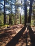
- For whatever reason, the directions we had in Google Maps led us to a small parking lot outside of the park along Burney Creek.
-
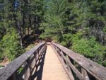
- The short trail led to the park loop trail with a bridge to cross Burney Creek.
-
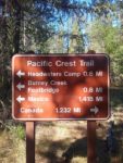
- The Burney Creek Footbridge is intersected by the PCT.
-
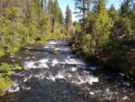
- Burney Creek – this leads down to the falls. This is a popular spot for trout fishing.
-
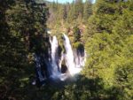
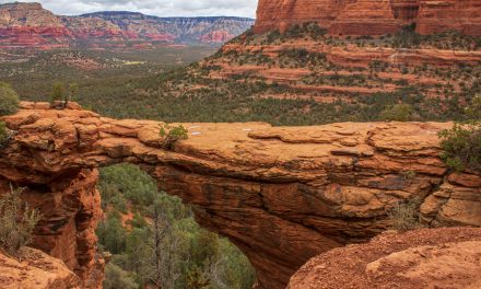
- The first views looking down to Burney Falls.
-
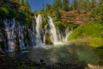
- There’s no caption that can describe this beauty.
Who HIking McArthur-Burney Falls Memorial State Park Is For:
Advanced Hikers: If you’ve got the time, consider the five miles of trails that lead past the falls and to the lake and back.
Expert Hikers: Even those hikers who are used to longer trails will be amazed by the beauty of Burney Falls. The PCT intersects the park and longer trails outside of the park can be accessed if you’re looking for a long hike.
It’s always a good idea to be aware of what type of hiking level you’re at.
Best Time Of Year To Hike McArthur-Burney Falls Memorial State Park:
Fall can usher in a changing of the seasons. The deep blue pond at the base of the falls can reflect the orange and yellow hues of the fall foliage in the surrounding forest. Winter can bring cold temperatures and icicles can form along the cliff of the waterfall. There are occasional storms that can completely blanket the park in snow. Photos of the falls next to snow covered land offer up a magical winter playground. Spring can bring vibrant colors with wildflowers. It is during the spring that the waterfall will be at its best due to snowmelt from the mountains. With the amount of runoff in the local mountains, water is plentiful to keep the waterfall flowing throughout the summer.
As with any trail, it’s always a good idea to check the weather before heading out.
McArthur-Burney Falls Memorial State Park Trail Conditions:
The trails surrounding Burney Falls are in great condition and maintained by the California State Park system. The trails nearest the waterfall are in the best condition. In fact, the path leading directly down to the waterfall viewing point is paved. There are also several informational plaques along the way down to the fall. There can be poison oak found along the trail edges in some areas. The odds of finding poison oak increase away from the trails that are directly near the waterfall. Rattlesnakes could be found in areas away from the falls with less foot traffic.
As a reminder, there are no pets allowed on trails within the park. The only exception to this is the Pioneer Cemetery Trail. This trail leads down to Lake Britton. All dogs must be on a leash no longer than six feet in length.
