
This trail is a moderate to heavily trafficked along the east end of Mission Trails Regional Park. The views along this route are typical of Southern California chaparral valleys. On a clear day a hiker at the top of Kwaay Paay Peak will be able to see downtown San Diego, Coronado Islands off of Mexico, El Cajon Mountain, and the other surrounding San Diego County Mountains. It’s a great place to catch either a sunrise or sunset and also come across some of the wildlife that frequent San Diego Valleys.
The peak itself lies in the heart of Mission Trails Regional Park. The park is the seventh largest urban park in the United States and encompasses over 7,200 acres and approximately sixty-five miles of trails. Kwaay Paay sits at 1,194 feet, making it the fourth tallest peak in the park. While this trail is still popular and can get crowded, it is a good option for those wanting to avoid the daunting task of dealing with the crowds on the neighboring, Cowles Mountain.
One A Personal Note:
This trail is lesser traveled than Cowles Mountain but still quite popular. The trailhead to Kwaay Paay sits near the Kumeyaay Lake/Campground and Old Mission Dam of the San Diego River. This popular landmarks connect to other trails within the park. If you’re looking for more distance than what’s offered in the trail, you can walk to some of the other trails from the base of Kwaay Paay after you’re done. For finding out more information, check out the Mission Trails Regional Park website.
Do you have any updates to the hiking trail or want to share your hike/pictures? Please leave a comment below.
- Overall Difficulty: 60%
- Overall Views: 70%
Kwaay Paay Peak Trail Quick Facts:
- Elevation: 1,994 feet.
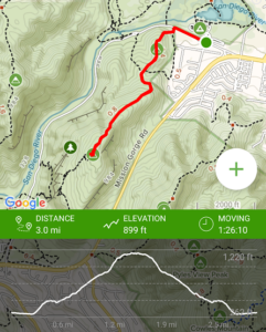
- Elevation Gain: 899 feet.
- Estimated Distance: 2.3 miles.
- My Actual Distance: 3.0 miles.
- Estimated Time: 1-3 hours.
- My Time: 1 hour 26 minutes moving. 2 hours 5 minutes total.
Kwaay Paay Peak Trail Directions:
Open in maps. To get to Kwaay Paay Peak you’ll need to proceed on to Junipero Serra Father Trail (which is actually an old road that cuts through the park along the San Diego River). The parking lot is at Mission Trails Parking Lot near the Kumeyaay Campground. The trailhead to Kwaay Paay Peak is a short walking distance past the parking lot along the Junipero Serra Father Trail. There is also some street parking closer to the trailhead but if it’s full, park in the lot. Here is the important thing to know: access to Junipero Serra Father Trail is gated.
The gates open at 8am but close at 5pm from November to March and 7pm from April-October. If you want to hike Kwaay Paay Peak after the posted hours, park outside the gate along the street of Junipero Serra Father Trail. There is plenty of street parking space.
Kwaay Paay Peak Trail Pictures:
-
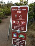
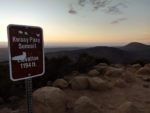
- Treailhead information and regulations.

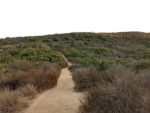
-
- The view of the bottom of the trail.
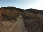
-
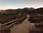
- Most of the trail of Kwaay Paay looks like this until the trail begins it’s final ascent at about 0.9 miles in.
-
- Looking up to the top of the peak.
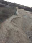
-
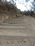
- This is the most difficult part of the ascent. The trail takes an upward ascent through a series of staircases like this.
-
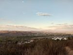
- A look to the Northeast showing the view of Santee and El Cajon Mountain.
-
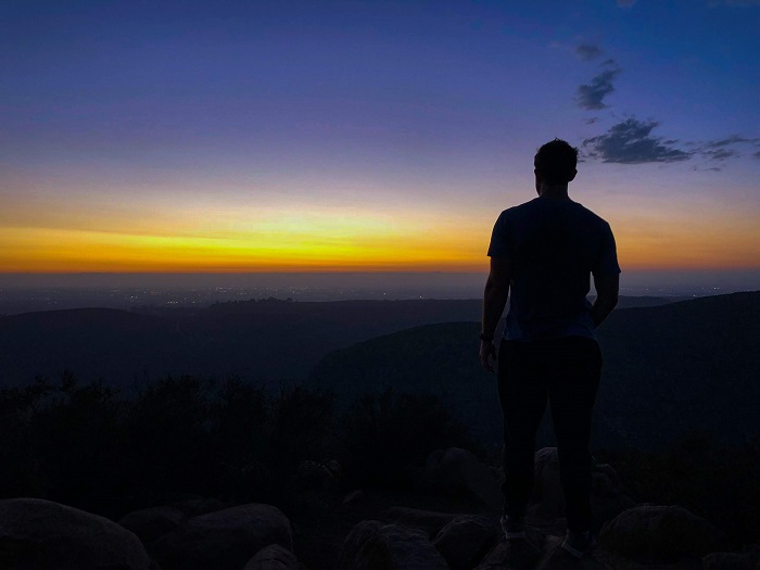
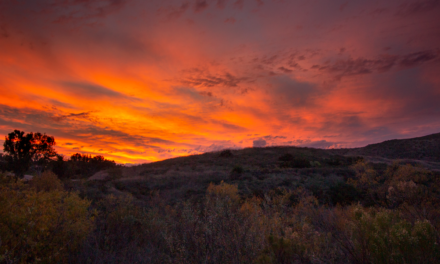
- Finally at the top to catch the sunset.This is the view looking straight to the west with the Fortuna Mountains in the background.
-
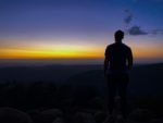
- Beautiful sunset colors.
Who Kwaay Paay Peak Trail Is For:
Advanced Hikers: This is a short trail great for getting your heart rate up in a short amount of time. The view at the top is worth the short trek.
Expert Hikers: Expert hikers will likely enjoy some of the longer and more difficult peaks in the park like South and North Fortuna. Don’t let this short trail be kept off your bucket list, however. It’s always a good idea to be aware of what type of hiking level you’re at.
Best Time Of Year To Hike Kwaay Paay Peak:
Late fall, winter, and up to mid-spring are the best times to enjoy this trail. Mid-spring after the winter rains bring new growth to the area will be the prettiest. Spring will also be the best time to view the green hills and wildflowers that bloom each year. If you hike this trail after a good rain, head across the street to check out the Old Mission Dam and the San Diego River at its peak.
Summer can be downright uncomfortable to hike this trail unless at dawn or dusk when the temperatures are the coolest. Fall days can be quite warm especially during Santa Ana wind events. Always be prepared for the conditions you’re about to hike in.
Kwaay Paay Peak Trail Conditions:
Kwaay Paay Peak is a straight forward out and back trail. The trail is composed of mostly dirt with some loose rocks and granite/wood steps along the way. The trail starts off with some mild elevation gain followed by a small saddleback at about 0.3 miles in. At 0.3 miles in there are two trail junctions that lead back down to the bottom but start from different points along Junipero Serra Trail. The west junction leads to the Old Mission Dam. From here on out it’s straight on up. The steepest of the elevation comes at near the one mile mark. From here granite steps and wood steps will mark the ascent to the top. The trail is completely exposed to the elements so prepare for lots of sun.
Once at the top you’ll be greeted with views of San Diego County as well as a sign naming the peak at the top. Enjoy the views and head back down. Rattlesnakes are common in Mission Trails Regional Park so keep an eye out for them. For the most part, this area gets too much sun and is too hot and dry to allow Poison oak to grow. It’s still good to be familiar with the plant just in case any starts to grow in on any shady undergrowth. The trail is maintained through both foot traffic and the Regional Park staff.