
Union Point Hiking Trail Guide
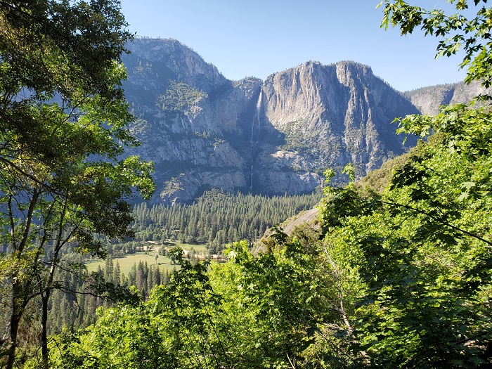
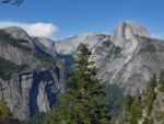
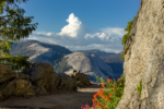
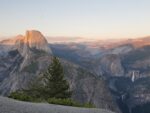
For many people the trip to Yosemite Valley can often be referred to with the metaphor along the lines of a journey to mecca. While Yosemite National Park is full of breathtaking views throughout the entire park, the valley is what draws its millions of annual visitors. One great place to take in some of these amazing valley views is from Union Point. Union Point is a popular viewing area that is along the Four Mile Trail. The views from Union Point are sweeping panoramic sights looking through Yosemite Valley to the west, directly across to Yosemite Falls, through to the east side of the valley, and the high Sierra above Yosemite.
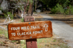
There are actually two different ways to hike to Union Point. Both routes are along the famous Four Mile Trail. One route trail access is from Yosemite Valley and the other is from Glacier Point. The history of the Four Mile Trail dates back to 1872 as an old toll trail to the top of the south valley. The trail led to a hotel at the base of the the trail. Originally the trail was four miles in length. Since then the trail was lengthened to 4.8 miles and deviated for safety reasons.
The most difficult way to get to Union Point is from the valley floor from the entrance to the Four Mile Trail. This route has the most elevation gain and is longer at about six miles long. The shorter route runs down from Glacier Point and leads down the Four Mile Trail to Union Point. This route has less elevation and is about three and a half miles in length. For detailed trail routes see the trail discription tab. During the winter the Glacier Point access is closed and the only way to access Union Point is from Yosemite Valley.
On A Personal Note
For those not wanting to do the entire Four Mile Trail, I highly recommend the hike to Union Point. Shorter in distance with less elevation this hike features expansive views of the entire Yosemite Valley and the Yosemite basin in the high Sierra. Some of the noteable sights from along this trail include Half Dome, Cloud’s Rest, Yosemite Falls, El Capitan, the Merced River, Vernal and Nevada Falls near Glacier Point, and many notable peaks in the high Sierra.
I got to Union Point by hiking the Four Mile Trail. I used Union Point as a place to take in the views and eat a sandwich. Amazingly I had the spot all to myself but I was hiking in the late afternoon during very warm weather. One thing I want to mention is that in the afternoon the sun casts a pretty big shadow onto Yosemite Falls. Those photography enthusiasts would have better lighting doing the trail in the morning when the sun hits the north valley wall.
Sources:
1. N.a. “Four Mile Trail.” Yosemite National Park. National Park Service. https://www.nps.gov/yose/planyourvisit/fourmiletrail.htm. October 2020. Accessed 11 November 2020.Do you have any updates to the hiking trail or want to share your hike/pictures? Please leave a comment below.
- Overall Views: 100%
- Overall Difficulty: 85%
Union Point Trail Quick Facts:
- Max Elevation: 7286 feet at Glacier Point and 6332 feet from Yosemite Valley.
- Elevation Gain: 954 feet from Glacier Point and 2427 feet from Yosemite Valley.
- Estimated Distance: Approximately 3.7 miles from Glacier Point and 6 miles from Yosemite Valley.
- Estimated Time: 1.5 to 4 hours depending on route taken.
Union PointTrail Directions:
Open in maps. The easiest way to describe this location is that it’s on the south side of the valley wall across the street from the Sentinel Beach picnic area and near the Swinging Bridge. If you’ve passed the Yosemite Valley Chapel, you’ve gone too far. There is parking along the street but it does fill up very quickly. The trialhead is marked and easily visible from the road.
Other options of accessing the trailhead are taking the park’s shuttle system if it’s up and running. You could also opt to park across the Merced River on the north side of the valley at the Yosemite Valley Lodge. Hiking across the valley will obviously add to distance and time, however.
Glacier Point Directions
Open in maps. Access to the trailhead is very easy at the end of Glacier Point Road. At the Glacier Point viewing area there is a paved ramp that leads down to the parking lot. At in the parking lot will be a trail marker pointing in the direction of the Four Mile Trail. The best option for reaching this vehicle will be getting dropped off by someone. If the park’s shuttle system is running, you can catch a ride here then hike down.
During the winters this road is closed due to heavy snowfall. Glacier Point Road does tend to open up earlier in the year than Tioga Pass. Please check with the park on the current road conditions if you plan on traveling when there may be snowfall. There is limited cell phone service in this area so know where you’re headed before you head deeper into the park.
For both trailheads, cost is admission to Yosemite National Park. An America The Beautiful pass will also work.
Union Point Trail Pictures:
-
- The start of the Four Mile Trail – easily marked.
-
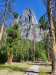
- A look up 3,000+feet towards the final destination.
-

- Some distance information.
-

- The trail begins in a fair amount of shade as near the valley floor.
-

- As the elevation climbs, the forest canopy thins out. One of the first views of Yosemite Falls – the views get better on the way up.
-

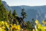
- Despite being up against the valley walls, there are a fair amount of wildflowers on the way up.
-
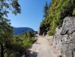
- Most of the trail on the way up is exposed to the sun.
-
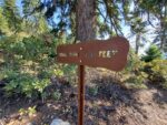
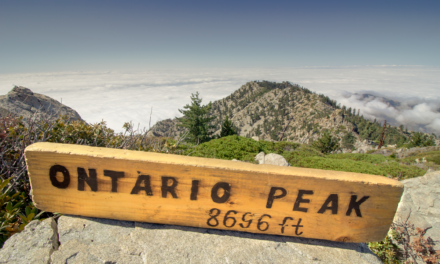
- The Marker for Union Point.
-
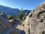
- Union Point is a great place to take a breather on the way up.
-
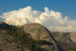
- A closer view of North Dome and a developing thunderstorm.
-

- The trail evens out close to Glacier Point and winds through a conifer voices.
-
- Take some time to enjoy the view and the waterfalls of the Mist Trail down below.
Who The Union Point Trail Is For:
Novice Hikers: For those hikers not wanting to experience the full difficulty that the Four Mile Trail offers this is a great option. Stick with the Glacier Point trail entrance as it is much easier. Remember, the elevation gain will be on the way back to Glacier Point so save some energy.
Advanced Hikers: The more difficult route will be from the Valley Floor. If you’re looking for a challenge, that is the option for you. If you have limited time, doing this trail from Glacier Point is a great option packed with views.
Expert Hikers: If you’re wanting to experience the full views of the hike, do the entire Four Mile Trail. It makes an excellent completion to go along with completing the Upper Yosemite Falls Trail. The views are just so surreal. For even those long distance hikers, this trail is a worthy of a challenge. Of course, if you’re really wanting to push yourself you’ll complete the trail both ways. Don’t sell yourself short if you only want to do the hike one way though. For those expert hikers looking for a more difficult challenge, consider the Panoramic Trail. That hike is a sixteen plus mile trek that connects the Mist Trail to the Four Mile Trail.
It’s always a good idea to be aware of what type of hiking level you’re at.
Best Time Of Year To Hike The Union Point Trail:
The best time of year hike this trail really depends on what you’re looking to get out of it. The most important thing to consider is the seasonality of the trail. Glacier Point Road is only open from around May to November. After the first major snow storms in the winter, the road closes to Glacier Point. Once the road is closed, Union Point is only accessible from Yosemite Valley. When the weather becomes cold enough, the trail is closed completely past Union Point due to lingering ice and safety concerns.. Sometimes the trail closes completely during snowy conditions. If you’re worried about weather conditions, check with the National Park Service.
The best time of year to hike this trail to view the waterfalls will be from April to around July. Depending on the snow pack for the year, Yosemite Falls can start tapering off by July and dry up by the end of the summer. The likelihood for ice along the trail decreases as spring progresses.
Summers can be quite hot especially against the granite walls of Yosemite Valley. The morning hours will be the friendliest in terms of shade provided by the tall valley walls. Once the afternoon comes the trail will be in a significant amount of sunlight and heat once you leave the valley floor.
Sun position will also affect the views. The morning sunlight will make the north valley walls and Yosemite Falls more visible. The afternoon lighting will highlight Half Dome and the park’s High Sierra. Thunderstorms are common any time of the year but especially during late spring and during the summer.
Always be prepared by checking the weather conditions before a hike.
Union Point Trail Conditions:
This trail is in great condition and mostly managed through the National Park Service and volunteer work. This trail guide will focus on both the Yosemite Valley and the Glacier Point trailheads. Union Point is clearly marked with a sign and is about ten yards off of the Four Mile Trail.
Union Point From Yosemite Valley
This trailhead is the most difficult way to reach Union Point. The hike from this entrance is six miles out and back with 2,427 feet of elevation gain. This route also has the most switchbacks. The trailhead begins off Southside Drive in Yosemite Valley just past the Sentinel Beach Picnic Area. The trail immediately heads away from the road and crosses the Yosemite Loop Trail and begins heading up the canyon walls. Once heading up the canyon walls, there is a brief period of time to enjoy in the shade before breaking out above the forest canopy.
The hike is mostly on carved out granite and old road from the original trail. The elevation gain begins almost immediately with the majority of the switchbacks towards the back half of the hike. Because of the total trail length to turn around from Union Point I actually recommend hiking the entire Four Mile Trail. If you can arrange it, have someone pick you up from the top of Glacier Point or use the shuttle system if it is up and running. Hiking the entire Four Mile Trail will be more elevation but the total trail distance will be shorter at 4.8 miles. After Union Point the switchbacks mellow out the last 3/4 of a mile.
Union Point From Glacier Point
Hiking to Union Point from Glacier Point is the easiest option. Remember that if hiking this route all the elevation gained will on the way back to Glacier Point so save some energy. This trailhead starts at Glacier Point and leads down the steep walls that make up Yosemite Valley. The total distance is about 3.7 miles with 954 feet in elevation gain on the way back up. Compared to the other route, this portion of the Four Mile Trail will offer the most comprehensive views along the hike. From Glacier Point there will be panoramic views of Yosemite’s high Sierra including Vernal and Nevada Falls. The views of Half Dome will be less restricted by the canyon walls and forest canopy than hiking from Yosemite Valley.
As the trail leads down closer to Yosemite Point the views of Half Dome become slightly obscured. However, the views of Yosemite Valley really open up. From Union Point there will be impecible views of Yosemite Falls and an entire east to west panoramic sight from Cloud’s Rest straight through to El Capitan and through Yosemite Valley. The odds of seeing a rattlesnakes along this trail are pretty small given the high altitude and short growing season. However, always keep your eyes open and be alert. There is no poison oak along the trail.
