
Pipiwai and Waimoku Falls Hiking Trail Guide
No trip to Maui is complete without visiting Haleakala National Park. Rising 10,023 feet above the ocean, the dormant volcano rises above sea level and composes the bulk of the land mass on Maui. The national park sits atop the summit and extends down a narrow sliver of the mountain to the eastern flank. There are two distinct districts within the park: the Kipahulu and Summit district. The summit district encompasses all activities near the top of Haleakala. The Kipahulu district lies on Maui’s more remote eastern side of the mountain. This district features usually rough coastal areas and lush tropical slopes with waterfalls and is where this hike is located.
The Pipiwai trail packs quite a punch. This hike winds approximately four miles through tropical rainforest along the ridge that follows Ohe’o gulch from what the Pipiwai stream flows through. The landscape along the hike resembles something out of a Jurassic Park movie. Included along this trail is a bamboo forest, a waterfall viewpoint of Makahiku falls, and the towering Waimoku falls.
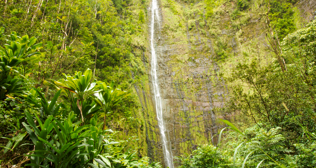
The Pipiwai hike climbs nearly eight hundred feet in elevation. The reward for those who complete the hike is the Waimoku waterfall which plunges about four hundred feet off the cliffs of Ohe’o gulch. For those not wanting to make the entire journey, fear not, there are plenty of views to be had. The viewpoint for the smaller Makahiku falls is approximately half a mile in. Another highlight of the trail is a dense bamboo forest where the trail is lined with wooden planks. While there take a moment to enjoy the hollow sound from the bamboo branches hitting each other from the blowing wind.
HALEAKALA HISTORY
In Hawaiian, Haleakala means, house of sun, which references the Hawaiian deity, Maui. . According to Hawaiian culture, Maui wrestled with the sun at the top of this volcano. The legend starts after Maui’s mother complained that there wasn’t enough light during the day to complete all her tasks. Maui took to the top of Haleakala and captured the sun with a hook and fishing line and secured him to a tree. The sun begged to be released but Maui would only do so if the sun promised to move more slowly across the sky and provide more daylight.
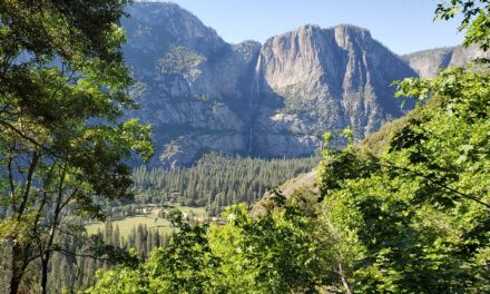
Legends aside, it’s the views from the summit of Haleakala that attract so many people. The pristine air is often clear, and to be honest, sunsets can be just as beautiful as sunrises from this location. However, sunsets are more often obscured by cloudy afternoons in the tropics. From the top of the mountain there will be 360-degree views. To the east, the mountains of Mauna Kea, Mauna Loa, and Hualalai on The Big Island will be visible. From sea level, Mauna Loa is also actually the tallest mountain in the world. To the west will lie the islands of Kaho’olawe, Lanai, and Molokai’i. To the east white fluffy clouds will line the horizon as the Pacific Ocean stretches out as far as the eye can see. As the sun rises it quickly paints the neighboring mountains and red volcanic craters of Haleakala in beautiful saturated colors. All while, the nearly eleven foot thousand mountain casts its shadow below.
On A Personal Note:
For anybody that makes it this far along the Road to Hana to the Kipahulu District I highly recommend this trail. I loved the waterfall but to be honest what I loved most about this trail was the dense bamboo grove. The grove filters the light through the leaves and produces green hues that radiate through the area. For those that make it near the stream, keep an eye out in the water for the freshwater goby. The goby is an endangered fish native to Hawai’i that uses suction from its mouth suction to climb steep waterfalls and work their way upstream.
When my wife and I completed this hike we made it to one of the main viewpoints for Waimoku falls. However, we didn’t follow the trail to the very end where the base of the falls is. Our busy itinerary and desire to view much more of the Road to Hana and explore the coastal portion of the district kept us away. Also when we went, the flow of Pipiwai stream wasn’t very strong and the viewpoint for Makahiku falls was unremarkable.
Keep in mind: There is no food or gas available in the park. Emergency services are also about an hour away. Plan accordingly.
Sources:
1. N.a. “Kipahulu District.” National Park Service. U.S. Department Of The Interior. https://www.nps.gov/hale/planyourvisit/kipahulu.htm. 24 May 2021. Accessed 10 July 2021.
2. N.a. ” Short Hike To Makahiku Falls.” National Park Service. U.S. Department Of The Interior. https://www.nps.gov/thingstodo/short-hike-to-makahiku-falls.htm. 18 December 2020. Accessed 10 July 2021.
- Overall Difficulty 55%
- Overall Views 100%
Pipiwai and Waimoku Falls Trail Quick Facts:
- Max elevation: 945 feet.
- Elevation Gain: 876 feet.
- Estimated Distance: 4 miles.
- My Actual Distance: 3.6 miles.
- Estimated Time: 1.5-3 hours.
- My Time: 1 hour 32 minutes moving; 1 hour 57 minutes total.
Pipiwai and Waimoku Falls Trail Directions:
Open in maps. Price to enter is the cost of admission to the national park. An America The Beautiful Pass will also work. Parking is at the Kipahulu Visitor Center. There is ample parking but the parking lot can fill up. The trailhead is at the parking lot. From there the trail crosses Hana Highway on the other side of the road and is visibly marked. The Hana Highway is a narrow two lane road so please be courteous and drive safe. Don’t forget that people call this place their home.
Pipiwai Trail and Waimoku Falls Pictures:
-

- The main parking lot for the Kipahulu District.
-

- The small visitor center.
-

- The trails are clearly marked. Follow the trail
-

- The narrow Hana Highway that the Pipiwai trail crosses.
-
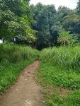
- From the trailhead the hike leads directly into the lush tropical forest.
-

- Flash flooding can occur. It’s best to use caution and heed the warnings.
-
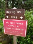
- Follow the signs. Fatalities have occurred from people falling into the gulch.
-

- For the most part the trail is soft dirt that can regularly get muddy after it rains.
-
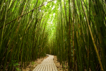
- The breathtaking bamboo grove.
-
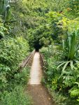
- There is a bridge that crosses the gulch before the waterfall.
-

- There is a brief stream crossing right before reaching the falls.
-
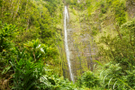
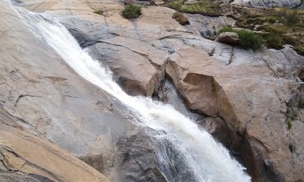
- Pipiwai falls.
-
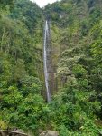
- A vertical photograph of Pipiwai falls.
Who The Pipiwai and Waimoku Falls Hike Is For:
Novice Hikers: For those with limited hiking experience, mobility difficulties, or poor physical physical condition may find this trail on the more difficult side. This trail isn’t long but it can be hot, humid, and muddy. If you feel comfortable with the distance and elevation gain, this trail is great. Novice hikers with some experience under their belt will enjoy this hike quite a bit.
Advanced Hikers: Those at this skill level will enjoy this trail a lot. Although this trail distance is not that long, this is a beautiful trail with amazing viewpoints.
Expert Hikers: The views along the trail are amazing. If you’re looking for more to do, enjoy some of the other trails nearby and along the Road to Hana such as the Twin Falls Hike.
It’s always a good idea to be aware of what type of hiking level you’re at.
Best Time Of Year To Hike Pipiwai Trail and Waimoku Fallsl:
Generally speaking, there is no bad time of year to hike this trail. Temperatures and weather are pretty consistent throughout the year with mild fluctuations between winter and summer. This portion of the island does receive a lot of annual rainfall. There can be no rain where the trail is located and rain in the higher elevations that cause flash flooding where the trail is. Rain and drizzle are common so come with those expectations. Afterall, there is a reason for the dense rainforest and persistent streams. Please be aware of the weather conditions in the area.
It’s always a great idea to check the weather before a hike.
Pipiwai Trail and Waimoku Fall Trail Conditions:
The Pipiwai trail is in generally great condition and maintained by the National Park Service. This hike is short but it packs a punch with many views. The hike begins right at the parking lot for the Kipahulu Visitor Center. Signs are clearly marked. The trailhead for the Seven Sacred Pools starts at the same area so be sure to follow the sign for the Pipiwai Trail. The trail will cross the narrow two lane Hana Highway before traveling up the hillside into the dense rainforest.
Along the trail will be a mix of grass and tropical trees. There is ample shade along the trail but the forest canopy won’t stop the rain from reaching the trail. With that being said, it’s not uncommon for the trail to be damp and muddy in parts. However, the ample rainfall is the reason for this trail’s beauty. Half a mile in there will be a marked viewing point for Makahiku Falls. This is a medium sized waterfall further downstream from Pipiwai Falls along the Ohe’o gulch.One mile through the trail will be a dense bamboo forest. The trail in this area is lined with wooden planks. Bamboo trees dozens of feet tall line each side of the trail. Filtered sunlight shines through the green leaves of the trees bringing about soft shades of green hues through to the ground. From the bamboo grove there is one more mile to go until Pipiwai Falls. There is a short bridge that crosses Ohe’o gulch.Prior to the falls there will be a crossing over Pipiwai stream. Rocks along the stream can be covered in algae and slippery so use caution. The higher the water level the more difficult the crossing will be. The water levels weren’t that high when I crossed. My best advice is to not be afraid to get your shoes wet. Pipiwai falls will be just after the stream crossing. The trail terminates at the base of the falls.