
Pyles Peak Hiking Trail Guide
Pyles Peak is one of the five peaks that make up Mission Trails Regional Park. This peak sits at an elevation of 1,379 feet making it the park’s second tallest. In order to reach Pyles Peak, one will first need to hike up to the very popular and park’s tallest peak, Cowles Mountain. This fact alone makes it a usually uncrowded peak as most people stop and turn around at Cowles Mountain. The good news is that a person can knock out two peaks if they’re aiming to complete the park’s Five Peak Challenge.
According to the San Diego Reader, the name of the peak dates back to 1989 and was likely to be named after the Pyle family (1). The family had an active role in convservation circles. From Cowles Mountain, the trail to Pyles Peak skirts along the western ridge of the peaks that make up the southwest side of the park. Atop the actual summit, there will be views of the other four peaks: Cowles Mountain, Kwaay Paay, South Fortuna, and North Fortuna.
There are three main ways to reach Pyle’s Peak through Cowels Mountain. The first one is through the most popular route off of Golfcrest Drive. This will be the most crowded route to get there. Total distance from start to finish will be 5.9 miles. The second way to reach Pyles Peak is from Big Rock Park in Santee. This route comes up the east flank of Cowles Mountain. The total distance this route is 7.5 miles. The Big Rock Park route will also be trail to take for those completing the Five Peak Challenge in one continuous trail. The third way to reach Pyel’s Peak is by hiking Cowles Mountain through the Barker Way trailhead. This route will lead up the south flank of Cowles Mountain for a total distance of six miles.
On A Personal Note:
Hiking to Pyles Peak can be enjoyable experience after having to deal with the crowd factor at Cowles Mountain. Many people turn around after getting to Cowles but if you want a little extra distance, adding this peak can put a couple extra miles on your legs.
Please be aware, there will be a loss of about 450 feet in elevation before having to climb 200 feet to Pyles. That elevation will be lost and another 450 feet elevation will have to be hiked to get back to Cowles. On an unfortunate note, the parking lot at the trailhead and along Golfcrest Drive is often littered with glass from lowlifes that vandalize cars.Have you recently done this hike? Please post your photos in or leave an update to the trail conditions in the comments section.
- Overall Difficulty: 70%
- Overall Views: 65%
Pyles Peak Trail Quick Facts:
- Estimated Distance: 5.9-7.5 miles.*.
- Total Elevation: 1,592.
- Elevation gain: 912 feet.
- Estimated Time: 2-5 hours*
*Total distance and time will depend on route taken.
Pyles Peak Trail Directions:
Open in maps. There is a very small parking lot at the entrance to the trailhead off of Golfcrest Drive that is often full. Street parking also fills up on Golfcrest Drive early in the morning and late in the afternoon near sunset. If street parking is full, people usually find parking along the street in the adjacent neighborhood. If you park in that neighborhood, please keep in mind that these are people with families that live here. Please be respectful to their neighborhood by limiting noise and garbage. As I mentioned earlier, unfortunately this trail can be prone to auto vandalism so use caution.
Via Big Rock Park:
There are a couple of options for reaching this trailhead. The first option is directly in Big Rock Park (open in maps). There is streetside parking along Mesa Road as well as the park itself. Here there is an obvious trailhead for Cowels Mountain. The parking along Mesa Road will be in a residential area so please be mindful and respectful of the people that live there.
The other option for parking is at the end of Big Rock Road (open in maps). This trailhead is even more immersed in a neighborhood so I’d advise for parking along Mesa Road. If you must park here, please be respectful of the people that live in this area. The hours for Big Rock Park are from dawn to dusk.
Pyles Peak Trail Pictures:
-
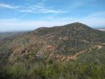
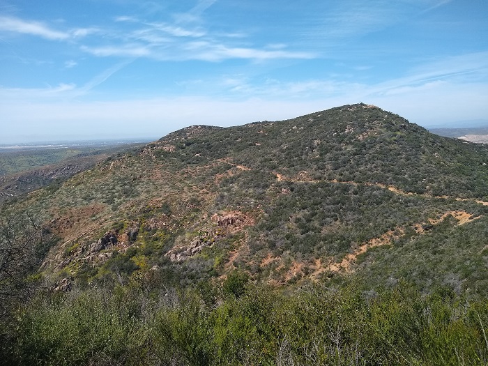
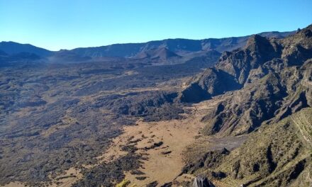
- Pyles Peak in the distance.
-
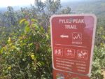
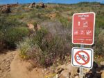
- Look for this sign along the maintenance road that marks the trail to Pyles Peak.
-
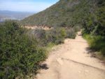
- Most of the trail looks like this with the exception of the actual incline to Pyles.
-
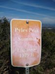
- The sign to head up to the peak.
-
- Now head back to Cowles.
Who Pyles Peak Is For:
Advanced Hikers: These type of hikers will enjoy the trek to Pyles Peak. The most enjoyable part of the trail will be leaving the crowds behind at Cowles.
Expert Hikers: If you really want to get some distance and elevation gain and loss close to the city, this isn’t a bad trail to do. If crowds really bum you out, consider the Fortunas.
It’s always a good idea to be aware of what type of hiking level you’re at.
Best Time Of Year To Hike Pyles Peak:
Pyles Peak Trail Conditions:
This trail is maintained by volunteer groups, general use, and through the Mission Trails Regional Park system. There is no cover from the sun along the trail so prepare accordingly. The trail on the Cowles Mountain side of things is a little crowded and loud to see any major wildlife. Rattlesnakes are common. There is no poison oak along the trail.
The trail is mostly made up of lose rock and dirt. To see the trail conditions from Cowels Mountain, see the individual trail routes. From Cowles Mountain the trail loses over four hundred feet of elevation before climbing another two hundred feet to get to Pyles Peak. Once there, enjoy the views and head on back!