
Hiking Torrey Pines State Natural Reserve
Separating the luxurious coastal towns of La Jolla and Del Mar sits a popular tourist and resident attraction, Torrey Pines State Natural Reserve. The reserve holds about two thousand acres of open space land along the coast. Several miles of hiking trails take visitors through Torrey Pines State Beach and through the ravines and bluffs that sit above the Pacific Ocean.
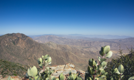
From the park’s high points, the coastline down to La Jolla Cove can be seen and to the north, the coast along the way to Dana Point can be seen. On a clear day San Clemente and Catalina islands can both be seen. On the reserve’s eastern side, the bluffs look upon the sprawling suburbs of northern San Diego County with its mountains in the background.
The protected land is home to a unique and rare species of tree known as the Torrey Pine. The hills are covered in native coastal shrubs and each spring wildflower blooms light up the hills with vibrant colors. The northern end of the reserve holds the also popular, Torrey Pines State beach and the Los Penasquitos Lagoon. The lagoon is home to many migratory birds and gets its water source from the Los Penasquitos Canyon directly to the east.
Torrey Pines State Natural Reserve History
Long before any European settlers explored this area, the region was predominantly inhabited by the tribe of Kumeyaay Native Americans. Early Spanish settlers during the 1500-1700’s referred to this area as Punto de Los Arboles, which means Point of Trees. The first modern account of the area was through a British medical doctor and botanist, Dr. Charles Christopher Parry. Parry was doing work for the United States-Mexico Boundary Survey. Parry named the tree the now famous Torrey Pine after one of his mentors and leading botanists of the time, Dr. John Torrey from New York. Surprisingly, Torrey never actually visited the area to see the trees and only had seen samples of seeds, branches, and cones.
Over the years the City of San Diego slowly acquired parcels of land which now make up what the reserve is today. The most notable of these acquisitions was from Ellen Browning Scripps, who has helped to make San Diego what it is today. In 1956 a special election was held that resulted in the land being given over to the State of California. Doing so allowed all the land, plants, and animals to have the complete protection that was needed. In 1959 Torrey Pines State Park became official. In 2007 the name became a reserve as opposed to a state park.
Torrey Pines Fun Facts
- A famous Spanish missionary, Junipero Serra and his expedition named the tree Soledad Pines (Solitary Pines) during their expeditions through the area in the 1700’s.
- The tree’s only natural habitat is found within this reserve and on the Santa Rosa island in Channel Island’s National Park.
- Torrey Pines have very large systems of roots to be able to tolerate growing in the dry and poor soil conditions.
- The nuts of the pine are edible.
- The height of the tree can grow upwards of fifty feet in the best growing conditions.
- One of the distinguishing characteristics of the needles is that they grow in groups of five.
For more information, call (858)-755-2063 or visit the reserve’s website.
On A Personal Note:
Although the reserve can get crowded, it does so with good reason. Torrey Pines is a beautiful reserve that gives the rare glimpse of what the coastal stretches of Southern California would look like without any human intervention. There are many routes and trails to take within the park to explore for people with all levels of hiking experience. I recommend parking in the north lot or at Torrey Pines State Beach. From there a full loop can be done hiking up through the park, down to flat rock, then along the bluffs to the state beach. Black’s Beach can also be reached to the south of the reserve (caution nudity).
Do you have any updates to the hiking trail or want to share your hike/pictures? Please leave a comment below.
- Overall Difficulty: 50%
- Overall Views: 90%
Torrey Pines State Natural Reserve Quick Facts:
- Elevation: 364 feet.
- Elevation Gain: 360 feet.
- Estimated Distance: 1-6 miles.
- My Actual Distance: 4.52 miles.
- Estimated Time: 1-5 hours (depending on route taken).
- My Time: 1 hour 52 minutes total; 1 hour 48 minutes moving.
***Estimated distance varies depending on route taken. Altogether the reserve holds several miles of trails. The north end of the reserve can be made into a loop down the reserve, to the beach, and across Torrey Pines State Beach.***
Torrey Pines State Natural Reserve Directions:
Torrey Pines Reserve Parking Fees and Hours
The reserve is extremely busy and the busy season starts during Spring Break until the end of September. Other holidays and weekends are also extremely busy. The visitor center and museum is open from 9 a.m. to 6 p.m. on weekends and 9 a.m. to 4 p.m. on weekdays. Hours within the reserve are from 7:15 a.m. to sunset every day of the year. during daylight savings time and Annual state park passes are also accepted at this site and are also available for purchase at the reserve for $195.
South Lot Parking
Parking costs during the busy season will be 15$ Monday-Thursday and $20-25 Friday-Sunday. During the low season, prices are $12 Monday-Thursday and $15 Friday-Sunday.
North Beach Parking
During the high season parking rates are $10 Monday-Thursday and $15 Friday-Sunday. Low season parking rates are $3 Monday-Thursday and $10 Friday-Sunday.
Thanksgiving and Christmas break is also a heavily trafficked time of year. For that reason, high season prices will be charged during that time of year. Holiday price for parking is $25 in the south lot and $20 in the north lot.
For more information, check out the state reserve’s website.
Torrey Pines State Natural Reserve Pictures:
-
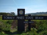
- The entrance to Torrey Pines State Reserve at the north parking lot.
-
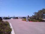
- The north parking lot.
-
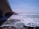
- Crossing under Torrey Pines Road where Los Penasquitos Lagoon empties into the Pacific Ocean.
-
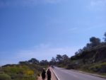
- Headed Torrey Pines Park Road to the visitor center
-
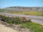
- Looking down from Torrey Pines Road into Del Mar and Los Penasquitos Lagoon.
-
- A higher vantage point of the view to the north.
-
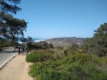
- Entering one of the many trails from near the visitor center.
-
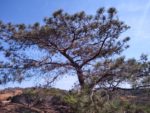
- The famous, Torrey Pine.
-
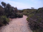
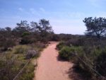
- Another portion of trails within the park. This one containing more rocks than sand.
-
- A view towards the south with the point of La Jolla Cove in the southern background.
-
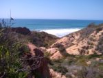
- Looking out into the vast Pacific Ocean.
-
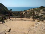
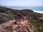
- One of the many canyon overlooks.
-
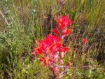
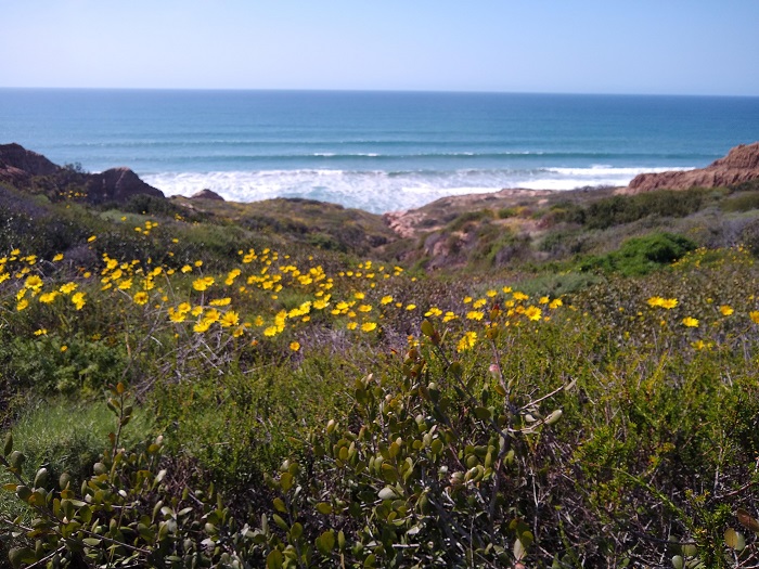
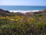
- Spring wildflowers in Torrey Pines State Reserve.
-
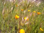
- The famous, California Poppy.
Who Hiking Torrey Pines State Natural Reserve Is For:
Advanced Hikers: Advanced hikers will find most of the trails throughout the reserve very simple and not very strenuous.
Expert Hikers: Don’t be deterred by the simplicity or the crowds. The wildflowers and coastal views are beautiful. String together some of the parks longer trails or hike in from the north lot if you’re wanting to add some distance.
It’s always a good idea to be aware of what type of hiking level you’re at.
Best Time Of Year To Hike Torrey Pines State Natural Reserve:
May and June may be some of the worst times to hike if it’s sun you’re looking for. “May Gray” and “June Gloom” is what locals refer to the overcast days during that frequently keeps the coast from seeing any sun during this time of year. To avoid the crowds, get there early, go during the week, and during the slow season.
As with any trail, it’s always a good idea to check the weather before heading out.
Torrey Pines State Natural Reserve Trail Conditions: