
Hiking Big Baldy Ridge Trail
The Sierra Nevadas are without a doubt one of the most impressive mountain ranges in the United States. Extending more than 250 miles long, this range is home to some of the most picturesque sites on the planet including the tallest peak in the contiguous United States. Sitting in the central Sierra Nevada are two incredible national parks: Sequoia and Kings Canyon National Park. The parks are home to gigantic trees, towering granite peaks, rivers, and meadows.
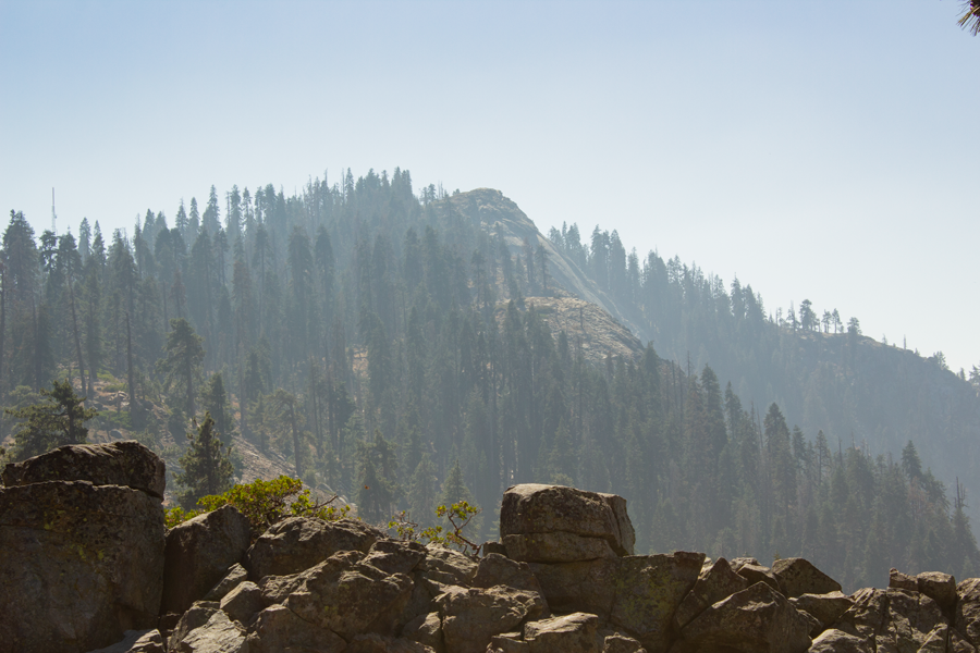
Big Baldy Ridge is a moderately trafficked trail offering panoramic views of some of the amazing sights in the area. On a clear day one could easily see deep into the Central Valley. To the east the towering peaks that make up the Sierra Crest will line the horizon. The peak of Big Baldy Ridge lies almost directly between the western edges of Sequoia National Park and Kings Canyon National Park.
The lure of the trail are the expansive views and large granite dome at the top. These domes were formed almost one hundred million years ago. Large swaths of molten rock slowly bubbled up from the earth’s inside. As it cooled, large dome rocks were formed throughout the Sierra range. It’s this same process that also formed Half Dome in Yosemite National Park.
On A Personal Note:
This is a wonderful hike that winds through the forests surrounding both parks. Unfortunately, when we hiked this trail, a severe fire in the southern end of Sequoia National Park was causing heavy smoke through the area. The smoke obstructed a lot of the peaks in the high Sierra as well as the Central Valley. On a clear day this hike would have amazing views.
There are no Sequoia trees along the trail. However, their tall canopies can be seen looking out from the ridge from the distance. See if you can spot them amongst the other conifers in the area. |
Looking for a hike with similar views? Check out the Moro Rock Trail. This is a short hike near the Giant Forest Museum and adjacent visitor center. This trail offers expansive views of the southern portion of the park, the Giant Forest, and the high Sierra peaks. It’s a great addition for those looking for short hikes to add to their day.
Do you have any updates to the hiking trail or want to share your hike/pictures? Please leave a comment below.
- Overall Difficulty: 70%
- Overall Views: 100%
Big Baldy Ridge Trail Quick Facts :
- Elevation: 8,035 feet.
- Elevation Gain: Approx 1,020 feet.
- Estimated Distance: 5.5 miles.
- My Distance: 4.9 miles.
- Estimated Time: 2-4 hours.
- My Time: 2 hours 11 minutes moving; 2 hours 26 minutes total.
Big Baldy Ridge Trail Directions:
Open in maps. Cost is admission to Sequoia National Park. An America The Beautiful pass will also work. The trailhead is located off of the Generals Highway. Technically this area is in Sequoia National Forest then the trail winds through a portion of Kings Canyon.
This trail can be accessed through both entrances to the parks. However, the location is closer to the Big Stump entrance than it is the Three Rivers area. Snow can fall at any time from early fall to late spring given the elevation. Prepare accordingly and know the weather ahead. Check with the park service for the current conditions.
Big Baldy Ridge Trail Pictures:
-
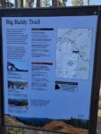
- An informative placard at the trailhead.
-
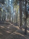
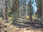
- Much of the first half of the trail is shadowed by tall conifers.
-
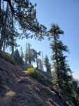
- As the trail climbs in elevation, the forest starts to thin a little.
-
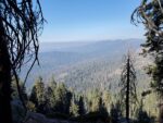
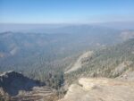
- Openings along the ridge give a great view looking toward the Central Valley.
-
- One of the first views of the ridge looking towards Big Baldy summit.
-

- A closer view shot with the camera.
-
- One of the last areas of forest before the top.
-
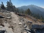
- The steepest part of the trail that leads directly up to the summit.
-
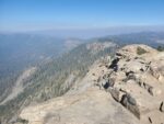
- Looking towards the northern Sierra towards Kings Canyon.
-
- A look more towards the rest with the foothills below.
Who Big Baldy Ridge Trail Is For:
Advanced Hikers: This is a great trail for hikers under this category. As far as advanced hikes are concerned, this trail is on the easier side of that spectrum.
Expert Hikers: If you’ve got a day to spend, do this short trail grouped together with other short or moderate sized trails in the area for a full day’s worth of hiking.
It’s always a good idea to be aware of what type of hiking level you’re at.
Best Time Of Year To Hike Big Baldy Ridge Trail:
There is ample amount of shade along the first half of the trail but the forest thins out as the elevation climbs. During the summer it wouldn’t be a great idea to be along the ridge during a thunderstorm with lightning. Spring will bring greenery and wildflowers to the meadows.
It’s always a good idea to check the weather before heading out on a hike.
Big Baldy Ridge Trail Conditions:
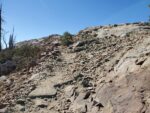
This trail is in excellent condition. The majority of the trail is made up mostly of loose dirt and small granite rocks. As the trail leaves the forest and winds along the ridge, the trail slowly becomes more rocky. Once near the dome the trail is almost completely all granite. There is no poison oak along the trail. Rattlesnakes shouldn’t be encountered but aren’t ever out of the question during the warmer months. Always be alert for bears.

