
Golden Canyon Trail Hiking Guide – Death Valley National Park
For those that have been to one of Death Valley’s most popular viewing areas, Zabriskie Point, they have no doubt looked down below on the colorful rolling badlands directly below. These rolling hills represent Golden Canyon and can easily be accessed from Badwater Basin Road. The Golden Canyon trail is a short out and back trail that starts below sea level and winds up through a shallow canyon and wash passing by a few notable landmarks.
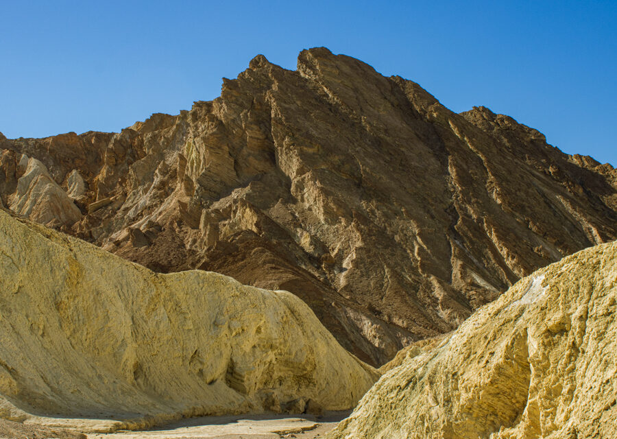
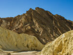
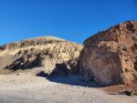
A few of the popular sights along this trail will be the golden mudstone and ash deposits from previous volcanic eruptions which give Golden Canyon its name. The halfway point of the hike will conclude with the towering Red Cathedral. Red Cathedral is an iconic view easily seen from Zabriskie Point. The tall reddish iron-stained cliffs are hard to miss as they rise into the sky. Before heading back down to the trailhead take a look to the east. Rising in a triangular fashion will be Manly Beacon, another popular and prominent feature seen from Zabriskie Point. The view from Golden Canyon offers a much more personal and closeup perspective of some of the sights seen from a distance at Zabriskie Point.
Although Golden Canyon is a shorter hike it is part of an overall longer trail network. Golden Canyon can be connected as a loop trail which extends the length to 7.8 miles total. The loop trail extends past Red Cathedral and Manly Beacon through rolling badlands composed of ash deposits. The badlands loop works its way up to the very popular Zabrsikie Point. From there connect with a trail down a narrow gulch called Gower Gulch. The gulch trail will circle its way back to the Golden Canyon Parking lot.
On A Personal Note
If you’ve made it up to Zabriskie Point to look down upon Golden Canyon, you’ll most likely get the itch to explore what you’re looking down onto. Hiking through Golden Canyon brings you up close and offers a different perspective on some of the landmarks that make Zabriskie Point popular. If you’re flexible on the time of day I recommend visiting Golden Canyon near sunrise or in the late afternoon close to sunset. The softer light will reflect deep reds and oranges mixed with golden beige hues throughout the area.
Looking for another hike nearby? Check out the Salt Creek Interpretive Trail. This short hike leads through a spring fed creek that supports a variety of wildlife including the Salt Creek Pupfish.
Have an update to this trail location? Leave a comment below.
- Overall Difficulty: 60%
- Overall Views: 95%
Golden Canyon Trail Quick Facts:
- Max Elevation: 322 feet.
- Elevation Gain: 456 feet.
- Estimated Distance: 2.9 miles.
- My Actual Distance: 2.9 miles.
- Estimated Time: 1-2 hours.
- My Time: 1 hour 12 minutes moving; 1 hour 19 minutes total.
Golden Canyon Trail Directions:
Golden Canyon Trail Pictures:
-
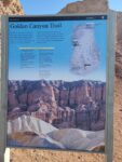
- The placard at the trailhead for Golden Canyon.
-
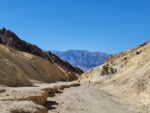
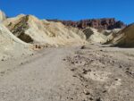
- Looking downwards through Golden Canyon and across to the Panamint Range.
-
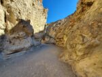
- Going through some of the taller aspects of Golden Canyon.
-
- Leading out of the canyon and approaching Red Cathedral.
-
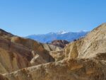
- A window through the rolling hills and looking towards a snowcapped Telescope Peak.
-
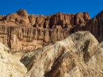
- At the base of Red Cathedral.
-
- Near the base of Manly Beacon which is a famous viewpoint from Zabriskie Point.
-

- The Golden Canyon trailhead parking lot.
-
- The trailhead into the canyon.
Who Golden Canyon Trail Is For:
Novice Hikers: This is a great trail for newer hikers. The elevation gain isn’t extreme. Please know that you also don’t have to complete the full length of the hike in order to experience the golden colors throughout the canyon. If you’re up to hiking longer distances, aim for as long as you’re comfortable with.
Advanced Hikers: Advanced hikers will enjoy the challenge of completing the full loop.
Expert Hikers: Like the advanced hikers, hikers of this level will also enjoy hiking the full trail system here.
It’s always a good idea to be aware of what type of hiking level you’re at.
Best Time Of Year To Hike Golden Canyon Trail:
One of the best things about visiting during the winter is seeing the view of Telescope Peak and the Panamint Range. These mountains are tall enough to catch residual weather systems coming off the Sierra Nevada. During the winter months the Panamint Range is often capped in snow and provides a nice contrast to the desert landscape. Once a decade or so enough rainfall will make its way into the valley to cause a rare superbloom with vibrant flowers.
Summer can bring about other problems besides just heat. The summer months is the monsoon season for the southwest desert. This season brings about the chance for lightning and thunderstorms. Avoid being out in the open during a thunderstorm to prevent being hit by lightning. It’s always a good idea to check the weather before heading out on a hike.
Golden Canyon Trail Conditions:
This hike follows a natural wash throughout Golden Canyon. Connecting trails for the entire network are marked by the National Park Service. Avoid going off the trail. The area has several washes and canyons dispersed between all the rolling hills in this area and it would be easy to get lost. Keep an eye out for rattlesnakes during the cooler hours or during the night.