
Badwater Basin Trail Hiking Guide – Death Valley National Park
Badwater Basin is high on the itinerary list for those visiting Death Valley National Park. The hike draws ample amount of visitors as it has several interesting highlights. This area is known for its large salt flats, being the lowest point in North America, one of the hottest places on the planet, and one of the driest places in North America. The elevation here is an astonishing two hundred eighty two feet below sea level making it one of the lowest places on the planet. For those Star Wars enthusiasts, Badwater Basin was the filming location for the Mos Eisley Spaceport where Luke met Han Solo for the first time in Episode IV. The view is most recognizable from Dante’s View five thousand feet above the basin.
Geologically, this large basin spans over two hundred square miles. It is formed by two large fault lines on opposite sides of the valley. With a trained eye, the fault lines are easily recognizable. In the west its marked by the Panamint Range with it’s towering Telescope Peak rising over eleven thousand feet in elevation. Immediately to the east is the Black Mountain Rage with its sheer vertical walls rising several thousand feet above the basin and the parking lot to the trailhead.
Badwater Basin is one of the hottest places on the entire planet. The mountain ranges on both sides of the valley essentially box in and trap air. As the air heats up and rises the tall mountain walls recirculate it throughout the valley and heat it up even more. Temperatures during the summer often exceed over one hundred and twenty degrees. Most of the rainfall here comes from monsoonal thunderstorms during the summer. Just to the east here is the tallest mountain range in the contiguous United States, the Sierra Nevada. The Sierra Nevada keeps Death Valley in a very large rain shadow. On average only two inches of rain fall here each year (1).
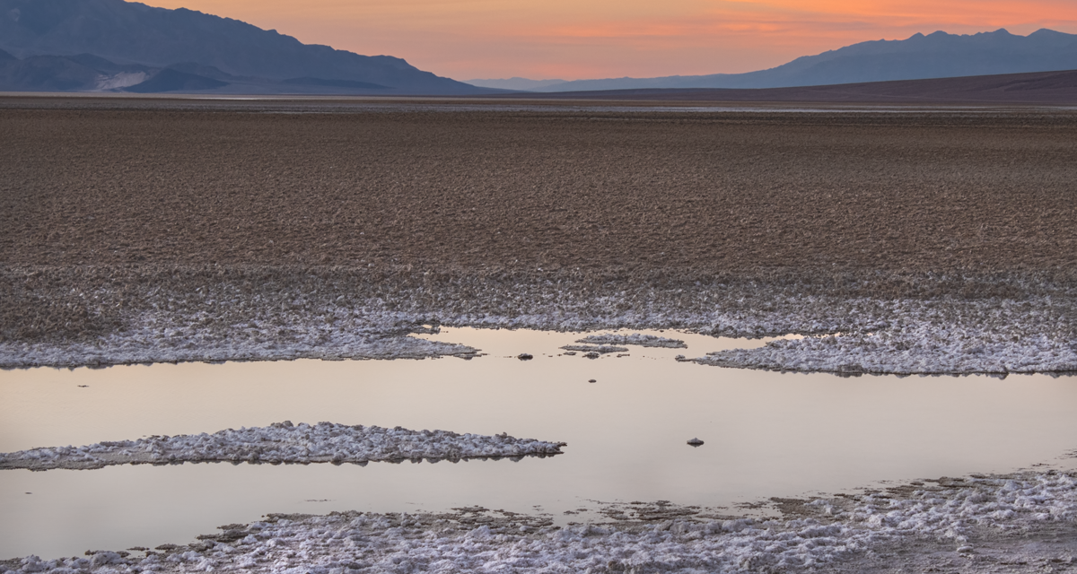
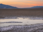
Another popular draw to Badwater Basin is the very large area of salt flats. Tens of thousands of years ago Death Valley was anything but the harsh desert environment that it currently is. Badwater Basin was once the site of the prehistoric Lake Manly. As the geologic processes took place, the lake eventually evaporated. What was left behind in its place was an abundance of salt and minerals. Today evaporating ground water adds to the evaporation process. As the water evaporates gemoetric salt polygons are left behind. The salt flats are primarily composed of sodium chloride, calcite, gypsum, and borax (2). These polygons are a popular photography subject.
On A Personal Note:
The best views of salt flats require about a two mile hike out into the open basin. While here don’t be surprised how hot these salt flats can be even during the winter. The amount of radiating heat off the white salt crystals is astounding. There’s also no reprieve from the sun here. A fair amount of UV light is also radiated off the white salt. I recommend sun protection.
Some near three hundred feet above the parking lot is a sign pointing out where sea level is. Also near the boardwalk is a small freshwater spring. All water here is high in salt and is collected in the higher elevations before its filtered to the ground water below. The salt flats make for some very creative and interesting pictures. The amount of salt in the basin can vary year by year depending on how much groundwater has evaporated from rain and snowfall throughout the year.
Sources:
1. N.a. “Birth Of Death Valley.” Death Valley National Park Placard. Exhibited at Badwater Basin February 2021.
2. N.a. “Badwater Basin.” Death Valley National Park. National Park Service. https://www.nps.gov/places/badwater-basin.htm. 27 June 2021. Accessed 20 February 2022.
- Overall Difficulty: 10%
- Overall Views: 95%
Badwater Basin Trail Quick Facts:
- Max Elevation: -272 feet.
- Elevation Gain: 3 feet.
- Estimated Distance: 2 miles.
- My Actual Distance: 2.1 miles.
- Estimated Time: 30–90 minutes.
- My Time: 53 minutes moving; one hour and three minutes total.
Badwater Basin Trail Directions:
Open in maps. Badwater basin is located in Death Valley National Park California. The exact location for the trail is on Badwater Basin Road. Located at the trailhead is an ample sized parking lot. Not all visitors hike the full distance out to the center of the salt flats so turnover in the parking lot is quick. Cost is admission price to the park. An America The Beautiful Pass will also work.
Badwater Basin Trail Pictures:
-
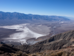
- Badwater Basin as viewed from over five thousand feet above from Dante’s View.
-
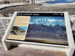
- A placard marking the beginning of the trail.
-
- One of the springs at the beginning of the trail.
-
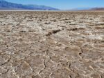
- At the start of the trail near the base of the mountain, the salt content in the soil is less than the middle of the basin.
-
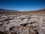
- The salt content slowly increasing.
-
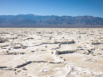
- Further into the salt flat the salt content is much higher.
Who Badwater Basin Trail Is For:
Novice Hikers: The most difficult thing about this trail will be the heat radiating off the bright white salt flats. The trail is flat and is more of a use path out to the center of the basin. This trail is great for those with families, those who are unable to hike longer distances or those with limited mobility.
Advanced Hikers: This is not difficult. Pair this hike with several other short hikes in the area or find a longer hike if you are looking for something more difficult.
Expert Hikers: Same as above.
It’s always a good idea to be aware of what type of hiking level you’re at.
Best Time Of Year To Hike Badwater Basin Trail:
One of the best things about visiting during the winter is seeing the view of Telescope Peak and the Panamint Range. These mountains are tall enough to catch residual weather systems coming off the Sierra Nevada. During the winter months the Panamint Range is often capped in snow and provides a nice contrast to the desert landscape. Once a decade or so enough rainfall will make its way into the valley to cause a rare superbloom with vibrant flowers.
Summer can bring about other problems besides just heat. The summer months is the monsoon season for the southwest desert. This season brings about the chance for lightning and thunderstorms. Avoid being out in the open during a thunderstorm to prevent being hit by lightning. It’s always a good idea to check the weather before heading out on a hike.
Badwater Basin Trail Conditions:
There is no trail here. It is more of a use trail that has been formed by the thousands of visitors that see this site. Not everybody hikes the full distance out to the center of the salt flats. The best views of the polygon geometric shapes are out towards the center of the salt flat. Feel free to venture as far as you want. Near the parking lot there is a boardwalk that overlooks the area and leads down to a saltwater spring at the base of the Black Mountains. The odds are quite low but it can’t be excluded, keep an eye out for rattlesnakes.