

Hiking Suicide Rock Trail
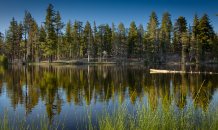
Over one hundred years ago the wildlands of San Bernardino and the mountain ranges of San Jacinto were declared National Forest land. Today, there are over 800,000 acres within this national forest. San Jacinto is a towering mountain over ten thousand feet. It is one of two neighboring mountains that separate the coastal Mediterranean climates from the southern Mojave Desert. Suicide Rock lies on the southwest flank of San Jacinto Mountain.
The trail to Suicide Rock begins along the Deer Springs Trail just outside of the northern part of the town of Idyllwild. Deer Springs serves as a major junction to several other hiking destinations including portions of the Pacific Crest Trail and the summit of San Jacinto itself. The hike to suicide rock gains almost 2,000 feet in elevation in three and a half miles. The end point is a towering granite cliff with panoramic views of the southern peaks of San Jacinto Mountain, the valley below, and to the coastal Santa Ana mountain range far to the west.
Caution would be advised sitting at the ledges as a slip and fall would result in likely falling over a thousand feet. The view is incredible, however and overlooks Strawberry Valley which spreads out into the basin of the town of Idyllwild. The coastal mountain ranges including the peaks of Palomar Mountain, Cuymaca Peak, and Santiago Peak can be seen in the far west. Depending on the time of year, the trail can offer flowing creeks, snow hiking, and bountiful wildflowers. The area usually presents a good opportunity for wildlife and bird viewing. For more details, see the trail conditions below.
On A Personal Note:
I thought this was a wonderful trail. The trail is in an area that does feature four seasons (by Southern California standards). Suicide Rock is a great option for those needing some nature and wanting to escape some summer heat. I hiked this trail in late July. When I arrived and arrived at the trailhead just around sunrise the temperature at the trailhead was in the mid 50’s.
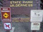
The 2018-2019 water year was very significant and Marion Creek was still flowing. There were still a few large areas of wildflowers towards the end cycle of their bloom. Please note, this is a trail that requires both a wilderness permit and either an Adventure Pass or America The Beautiful Pass to hike. More information can be found in the trail directions.
Do you have any updates to the hiking trail or want to share your hike/pictures? Please leave a comment below.
- Overall Difficulty: 85%
- Overall Views: 100%
Suicide Rock Trail Quick Facts:
- Elevation: 7,428 feet.
- Elevation Gain: 1,929 feet.
- Estimated Distance: 7 miles.
- Estimated Time: 3-5 hours.
- My Time: 4 hours 8 minutes total.
Suicide Rock Trail Directions:
Part of the trail is managed by the National Forest Service and the other part is managed by the California State Park system. So, that means, in addition to the America The Beautiful Pass, you’ll also need a Wilderness Permit. These permits are free, there is no quota, and you can fill this out the day of the hike. For camping permits you will need approval and at least ten days advanced noticed. Camping permit information can be found here.
Day of trail permits are easy to obtain. They can be filled out any time of day right outside the Idyllwild San Jacinto Ranger Station. There is a box with permits right outside the opening doors. Keep the carbon copy for yourself and put the top copy in the box.
Suicide Rock Trail Pictures:
-

- The small dirt parking lot to the beginning of the trailhead.
-
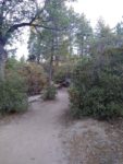
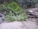
- The trail starts out in a mix forest of oak, pine, and manzanita groves.
-
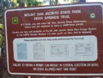
- Handy trail information.
-
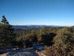
- One of the first open views of the trail. Looking west across Idyllwild, Hemet, Temecula, and Palomar Mountain in the far distance.
-
- There is ample amount of shade along the trail.
-
- As the trail increases in elevation, the trees thin out into conifer forests with scattered manzanita.
-
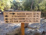
- The only junction along the trail. Keep right to get to Suicide Rock.
-
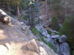
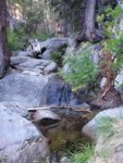
- In late July there was still water in Marion Creek.
-
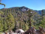
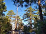
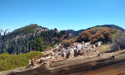
- Along the last stretch of trail overlooking Marion Mountain.
-
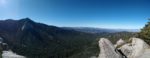
- From the top of Suicide Rock looking throw Strawberry Valley to the west with Palomar Mountain and the Santa Ana mountains in the far distance.
-
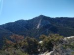
- Looking across Strawberry Valley to Tahquitz Peak with Lilly Rock in the foreground.
Who Suicide Rock Trail Is For:
Advanced Hikers: This trail is great for advanced hikers. Some advanced hikers might find this hike to be on the easier side.
Expert Hikers: This is a fun way to spend a morning or evening to catch some great views. This trailhead connects to many other areas within the region that would be fun for longer or even overnight hikes.
It’s always a good idea to be aware of what type of hiking level you’re at.
Best Time Of Year To Hike Suicide Rock:
During the fall, temperatures can become cool in the morning and throughout the night. In the lower elevations, the trees can put on a display of fall colors. Winters can be cold and stormy. The higher elevations can have light to moderate snow cover. The rainfall and snow will bring the seasonal creeks back to life. Seasonal creeks last until the late summer on a good year. Spring can have a wide variety of wildflowers up until mid-summer.
It’s always a good idea to check the weather before heading out on a hike.
Suicide Rock Trail Conditions:
The trail follows the ridge line of Deer Springs Creek. About half way up the trail comes to a junction. Take a right at the junction to continue to Suicide Rock. Going left will continue up Deer Springs Trail to the Pacific Crest Trail and many other trails in the area. There is one creek crossing along the trail. During late July when I hiked, there was still a small amount of water flowing. Use caution during and after storms as the creek crossing could be more treacherous.
As the trail continues up to Suicide Rock the views begin to open up. There will be a full panoramic view looking over Marion Ridge to Marion Mountain and Tahquitz Peak including Lilly Rock. Suicide Rock itself overlooks Strawberry Valley and Strawberry Creek a couple thousand feet below. Strawberry Valley opens up into the town of Idyllwild. Looking west will be the mountain ranges of north San Diego County and the Santa Ana Mountains. There is no poison oak along the trail. Always use caution and keep an eye out for rattlesnakes.
