
Hiking The Subway via Left Fork Trail in Zion National Park
When I show people pictures of the trail to the Subway, many people are amazed at beauty that this place holds. Many of them have heard of Zion National Park but few of them have heard of The Subway hike. The location of the hike is within Zion National Park but far from the park’s main entrance of Zion Canyon. To access the Subway there are actually two routes. The north and the south route. The north route is a lot more technical and requires canyoneering and rappelling experience. This article will be talking about the south trailhead to the Subway via the Left Fork of North Creek.
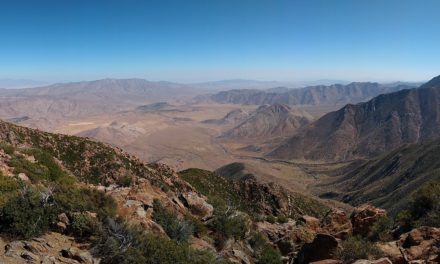
The bulk of the trail that makes up The Subway is through the canyon and along the Left Fork of North Creek. The creek lies within a deep canyon system. Over time heavy flash floods and natural erosion carved out a lot canyon about five miles in from the start of the trail. The forces of water through the canyon carved out short hollow tunnel that resembles that of which a subway would pass through – hence then name. The Subway is quite beautiful and over time it has become quite popular with photographers and hikers. This trail does require a permit so if it’s something you’re thinking about, please read about obtaining one.
On A Personal Note:
I had seen pictures of The Subway on Instagram in the past and when my fiance and I planned a trip to Zion National Park, this trail was at the top of the list for me. I too wanted to come to this trail and spend some time photographing it and see its beauty. Some blogs state that the hike up through the canyon can be challenging but I actually found it to be quite peaceful and nice. The most difficult part of the hike is the four hundred foot elevation gain to get out of the canyon at the end. Prior to reaching the subway there are also a series of mini-escalator waterfalls that are beautiful. Many websites also say that the trail is difficult to find the way up out of the canyon on the way out but I found it to be pretty easily marked.
- Overall Difficulty: 70%
- Overall Views: 100%
The Subway via Left Fork Trail Quick Facts:
- Elevation: About 5,000 feet.
- Elevation Gain: About 400 feet.
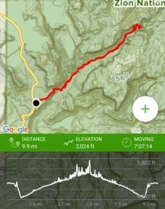
- Estimated Distance: 9-10 miles.
- My Actual Distance: 9.9 miles.
- Estimated Time: 6-9 hours.
- My Time: 7 hours 7 minutes (moving), 8 hours 20 minutes total.
(The GPS track is out of whack on this hike because the signal gets lost in the canyon and inside The Subway).
The Subway via Left Fork Trail Directions:
Open in maps. Getting to the Subway is quite simple and in my opinion, a lot easier than getting to other trails within Zion Canyon through their Shuttle Service. The trailhead is actually not located in Zion National Park but it is along the park’s Southwest flank along Kolob Terrace Road. There is a small dirt parking lot off this road which is the Left Fork Trailhead into North Creek.
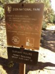
Getting down to The Subway does require a bit of advanced planning. To limit trail erosion, access, and to keep track of people going in and out of The Subway, the National Park Service does require that all hikers poses a valid permit. The permit is a lottery system that runs from April to October. Between the months of November through March there is no permit required to hike The Subway based off of low demand. To apply for a permit there is a $5 non-refundable application fee. Group sizes are limited to twelve people.
The earliest to enter the advanced lottery is ninety days. The Park Service will allow you to select up to three dates and rank them in order of priority. Dates do fill up quickly and are more popular on the weekends. If all the dates are taken, there is a last minute lottery drawing between two to seven days prior to the trip date with a small number of reservations. Sometimes, walk-up permits may be available. Walk-up permits are more likely to be available during the middle of the week and before and after the summer months.
Picking Up Subway Permits
Getting approved to hike The Subway is just the first part of being able to get out on the trail. Once a reservation is obtained, the permit needs to be picked up from either the Zion Canyon or Kolob Canyon Visitor Center inside of of the park. Permits can only be picked up during their business hours and will be an additional fee based off the number of people in the group.. The park service will send an email with the detailed instructions. I picked up my permits at 8am at the Zion Canyon Visitor Center prior to hiking Observation Point. When hiking, keep your permit on you at all times.
For more information about obtaining Subway Hiking Permits, please check with the National Park Service for more information and to see their list of any exclusion criteria.
The Subway via Left Fork Trail Pictures:
-
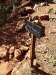
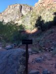
- The sign posted at the parking lot to the Left Fork of North Creek Trail.
-
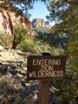
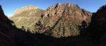
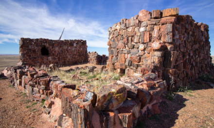
- This isn’t Zion Canyon but it is part of the Zion Wilderness which requires a permit.
-
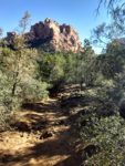
- The first portion of the trail headed out to the edge of the canyon.
-
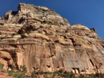
- As you head to the edge of the canyon, you’re eventually greeted with this canyon wall. Here you have to head down about four hundred feet down the canyon.
-
- Looking down the canyon.
-
- Looking up the canyon. Hint: it’s steeper than it looks.
-
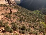
- Looking across the canyon of North Creek.
-
- The view of the sun coming up from down near the creek inside the canyon.
-
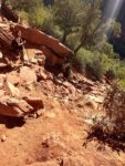
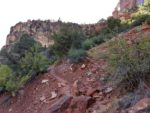
- The trail down is a dirt and loose rock trail that can be a little nerve-wrecking at times.
-
- This is where the trail leading down to North Creek heads and where the journey to The Subway begins. Remember this spot.
-
- Remember this spot to find the trail up out of North Creek.
-
- Where you’ll need to head back up the canyon later.
-
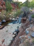
- Much of the trail looks like this where there will be hiking along the creek and inside of it.
-
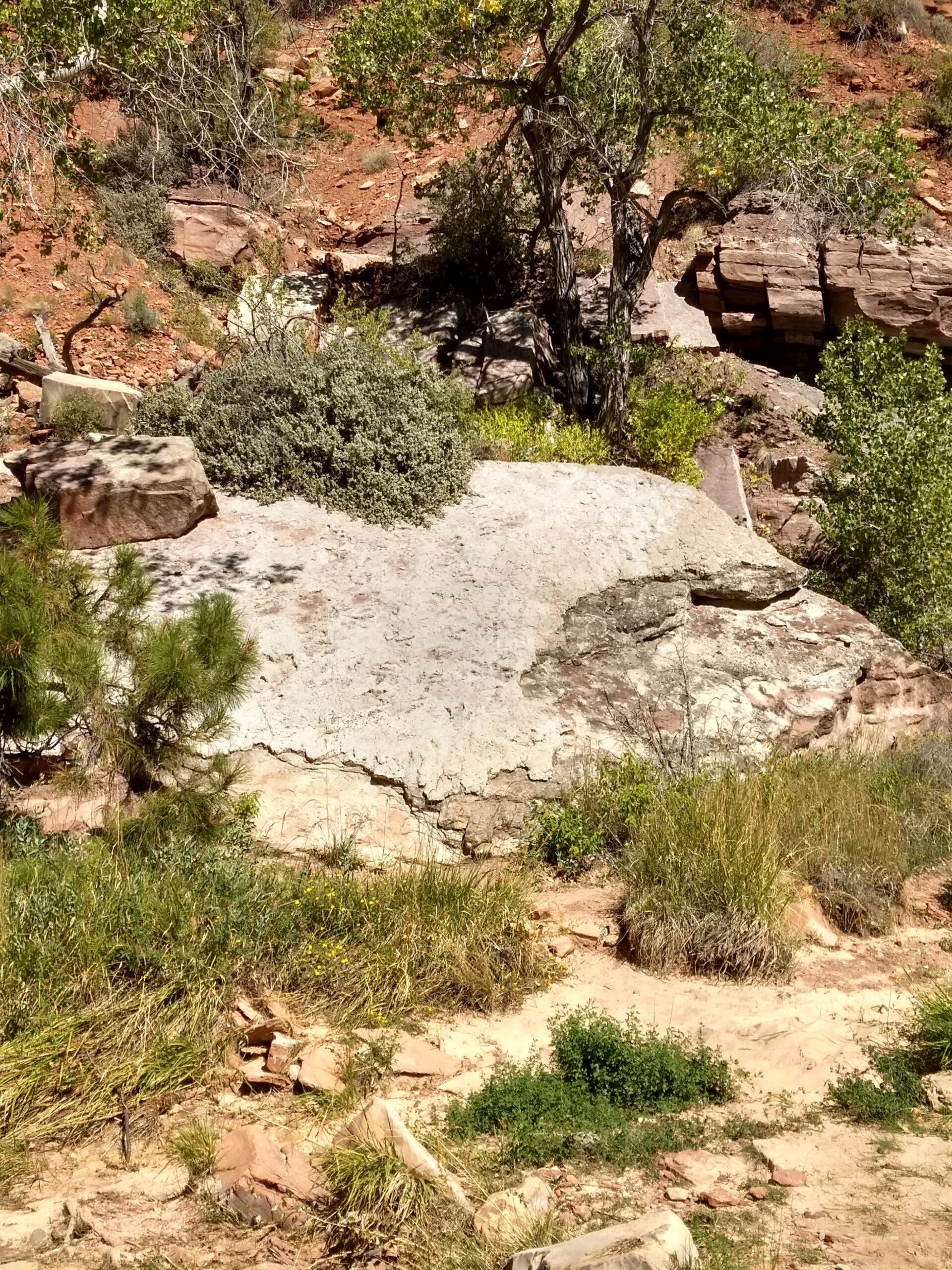
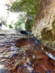
- A few miles into the trail, look for this rock. Honestly, it doesn’t look like anything until you realize it’s fossilized dinosaur foot prints. I thought it was pretty neat.
-

- This picture makes it look small but it is bigger than my hand.
-

- Looking up the creek.
-
- Some spots are tricky to navigate and require some boulder hopping.
-
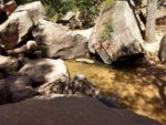
- More boulder hopping.
-
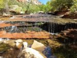
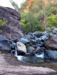
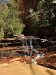
- The first false escalator waterfall.
-
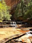
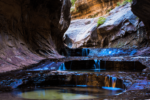
- This is the main elevator waterfall which has been famously photographed by some amazing photographers.
-
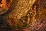
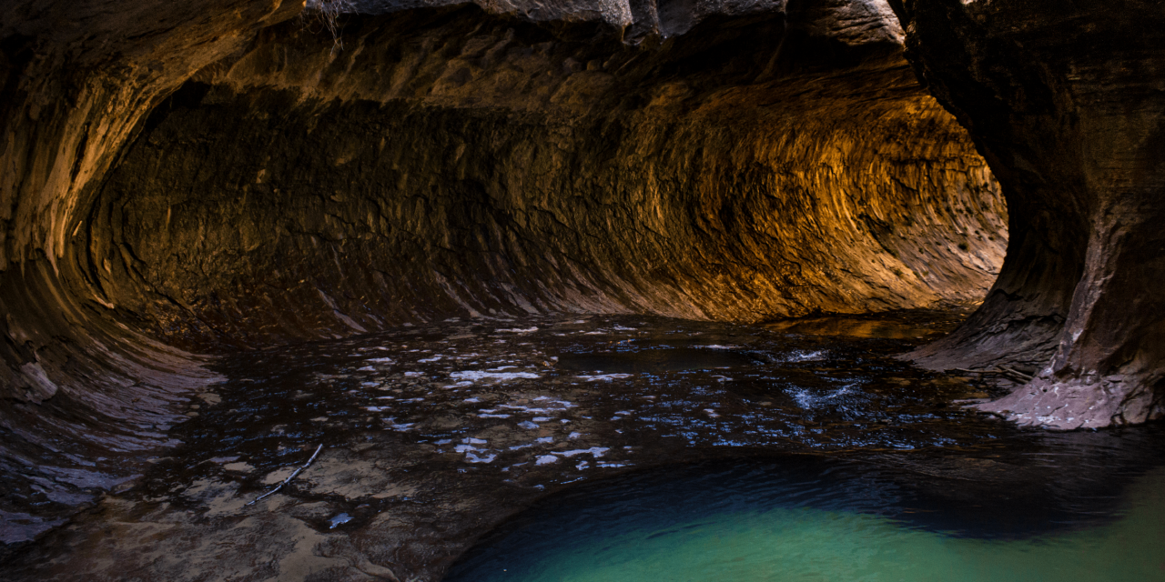
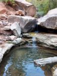
- When you reach this point, you know you’re close to the subway . This place is actually a HUGE half tunnel carved out of the canyon by water.
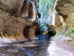
-
- Finally at The Subway. This is looking out of the subway.
-
- Looking into The Subway from the same spot.
-
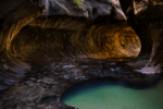
- The heart of The Subway.
Who The Subway via Left Fork Trail Is For:
Novice Hikers: This is a very difficult hike for new hikers but I don’t think that this trail would be impossible for all for all that would consider themselves in this category. If you have some minor hiking experience under your belt and a moderate level of fitness, this hike is definitely doable. If you do decide to do this hike, please go with someone who has advanced hiking experience. This hike does require a moderate level of trail navigation, boulder scrambling, and significant portions of this hike are through a creek and not a trail.
Advanced Hikers: This is an incredible hike for advanced hikers. Hiking in the creek gave me the feeling that this trail was an adult playground. Navigating what side of the creek to hike on or whether or not to just hike in the creek was a fun challenge. There was a minor amount of boulder scrambling on exposed rocks throughout the trail.
Sometimes it’s inevitable that you’re going to be hiking in water. My fiance didn’t mind getting her hiking shoes wet. I used mesh water shoes through some portions of the trail. The cool water was welcome on a hot September day. Use caution when walking through the creek. Some rocks are very flat and are covered in algae and are incredibly slippery.
Expert Hikers: This is an ideal hike for expert hikers.
It’s always a good idea to be aware of what type of hiking level you’re at.
Best Time Of Year To Hike The Subway via Left Fork Trail:
Hiking conditions can vary throughout the year. Ideally, late spring, summer, and early to mid-fall can be the best times of year.
Winter:
Winter is probably one of the least crowded times to catch this trail. That’s for obvious reasons. Sometimes winter storms can make the road leading up to the Left Fork Trail impassable. A powerful winter storm can drop snow and ice along portions of the trail. The water that also runs through the creek can be extremely cold this time of year. If the creek is at a safe enough level and the conditions aren’t treacherous, the hike is possible. Although you might want some neoprene socks and some other gear to keep from getting frostbite. Prepare for cold weather.
Spring:
Spring can be a great time to hike this trail – particularly the closer it gets to summer. Mornings and evenings will be particularly cool so prepare for layers. Snow melt can still make the water incredibly cold in the creek. In late spring early monsoonal thunderstorms can make an appearance which will increase the risk of flashfloods in the creek. If there is a threat of thunderstorms, don’t attempt this trail.
Summer:
Summer can be quite nice to hike this trail but it’s also some of the busiest season and hottest temperatures. The canyons are so tall that the water in the creek remains cool. The cool water can be a welcome relief for the hot temperatures. I recommend to start this trail a little after sunrise. Hiking back a little later in the afternoon can have the sun casting shadows from the west walls of the canyon and minimize sun exposure. Monsoonal storms are common during the summer and if there are thunderstorms, don’t attempt this hike. The last thing you want is to be caught in the canyon during a flashflood.
Fall:
Fall is probably one of the best times to hike in Zion National Park. The hot summer temperatures begin to fade as winter draws near. Mornings and evenings get cooler and the hot day time temperatures aren’t as unbearable. Early fall thunderstorms can still be a possibility. The summer crowds have left which makes the park more pleasant. As winter gets closer the water in the creek becomes colder. The trail will have some nice fall colors.
The Subway via Left Fork Trail Conditions:
The trail leading down to The Subway is a very well maintained trail. Maintenance is both through moderate use of the trail and through park maintenance. The trail begins in a small gravel parking lot off of Kolob Terrace Road. From there the first half a mile or so leads straight out on a well defined rock and dirt path until the Left Fork Trail takes a steep descent down the canyon. Use caution when going down the canyon – it is very steep! There are many loose rocks along the trail and a slip here could be disastrous. Save some energy for the end of your hike when this steep canyon greets you on your way out.
Hiking Up North Creek To The Subway
Once at the bottom of the canyon, you’ll end up right alongside North Creek. Head north at this point (to the left) and hike up the creek until you reach the subway. It is very important that you remember where to head back up the canyon! There are stories of hikers who have gone past the Left Fork Trailhead and kept hiking down the creek instead of going back up the canyon. When I did this hike there was a ribbon attached to a tree here but we also took pictures of the landmark. There’s also a small sign that says, Left Fork Trail as a marker.
From this point on the rest of the trail is along North Creek. There will be a series of trails alongside the creek either on the left or the right side. Most of these trails are very well defined and other times they will come to a head and disappear. The trails are a mix of dirt, loose rocks, scrambling through some trees, and some minor boulder hopping. The close to The Subway that you get, the more difficult the trail is to follow. At times it’s almost easier to hike in the creek. There will be a certain point where it’s inevitable that you can only hike in the creek. Use caution walking in the creek. Many of the rocks are covered in algae and incredibly slippery. The last thing you want is an injured foot on this remote hike.
Fossilized Dinosaur Prints
About three miles up along the river is very large white boulder. Honestly, this boulder just looks like a very large, white rock. Upon closer inspection though, the flat surface of the rock is littered with dozens of fossilized dinosaur prints. This large white rock will be on the west facing side of North Creek. Check it out, it’s pretty neat. But in order for other people to keep enjoying the prints and prevent erosion, do not sit or climb on top of the rock.
Enjoying The Subway
You’ll know you’re getting close to the subway when you reach a series of small escalating waterfalls no more than a couple of feet high. This spot is actually quite beautiful and a great place to enjoy lunch. Many people have capture some amazing photos of this exact spot. After this the trail begins to become more tube like until you finally reach the entrance of The Subway.
The Subway is a very unique place and has some amazing natural colors. I’ve read stories about this place being quite crowded but I was lucky on this day. There was nothing but a handful of people here and along the trail the entire day. Take some time enjoying the large cavernous tube that was carved out of the earth by water over time. Some people will jump in the small ponds along the trail. For hikers, this is where the trail ends and you’ll need to turn around. For those that are willing to get wet (warmth permitting), there is a small waterfall room shortly after the trail ends. Please do all you can to preserve the beauty of this area.
Please be aware that rattlesnakes can be found in this area. This region is generally too far out of the range for poison oak but there can be poison ivy in this park especially near the creek. Keep an eye out for other large species of wildlife like dinosaurs as well.